(English version) Solomon Islands Delimitation of Marine Waters Act, 1978 (Act No. 32 of 21 December 1978)
- Summary
This legal document contains Solomon Islands' Delimitation of Marine Waters Act, 1978 (Act No. 32 of 21 December 1978) promulgated in 1978. This Act includes, inter alia, the definition of, the demarcation of, the legal characteristics of, and regulations regarding the internal water, archipelagic water, territorial sea, exclusive economic zone, and continental shelf of Solomon Islands and the rights and responsibility of Solomon Islands as well as other states in the mentioned maritime zones of Solomon Islands.
Notably, regarding the delimitation of the territorial sea, this Act specifies that as the median line between Solomon Islands and Papua New Guinea is less than 12 nm from each state's territorial sea baseline, the territorial sea of Solomon Islands in the said area "shall be those declared by the Minister by order published in the Gazette." Moreover, this Act also clarifies that Solomon Islands opts for the use of median line for the delimitation of EEZ with adjacent/opposite states.
Specific coordinates constituting the straight baselines that determine the outermost limit of Solomon Islands' archipelagic water and the innermost limits of Solomon Islands' territorial sea of the archipelagos of Solomon Islands are provided in Solomon Islands' Legal Notice No.41 of 1979.
- Document: Solomon Islands Delimitation of Marine Waters Act, 1978 (Act No. 32 of 21 December 1978)
- Related Document: Solomon Islands Legal Notice No. 41 of 1979: Declaration of Archipelagic Baselines
(English & French) Agreement on maritime delimitation between France and Solomon Islands, 12 November 1990
- Summary
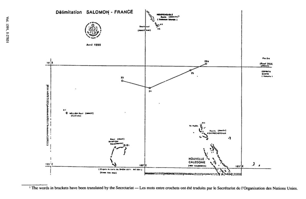
This legal document contains the English and French versions of the Agreement on maritime delimitation between France's territory of Caledonia and the Solomon Islands, signed on 12 November 1990. The description of the maritime boundary and specific coordinates constituting the line are listed in Article 1 of the Agreement.
- Document: Agreement on maritime delimitation between France and Solomon Islands, 12 November 1990 (English & French)
(English & French) Treaty Between the Solomon Islands and Vanuatu Concerning Maritime Boundaries, 7 October 2016
- Summary
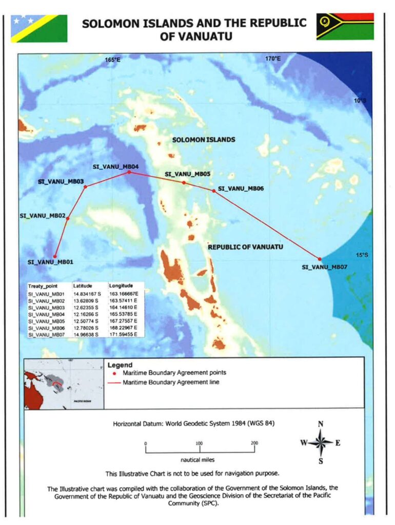
This legal document contains the English and French version of the Treaty Between the Solomon Islands and Vanuatu Concerning Maritime Boundaries, signed on 7 October 2016.
Article 1 describes the maritime boundary between the Solomon Islands and Vanuatu and provides the specific coordinates constituting the line.
Notably, the Treaty's Article 5 states that if the basepoints coordinates are shown to be significantly changed by new surveys, both Parties will consult "with the view to agreeing upon any necessary adjustments" to the maritime boundary in this Treaty, and thereby provides provisions for future adjustment of the demarcation line (i.e. due to rising sea level).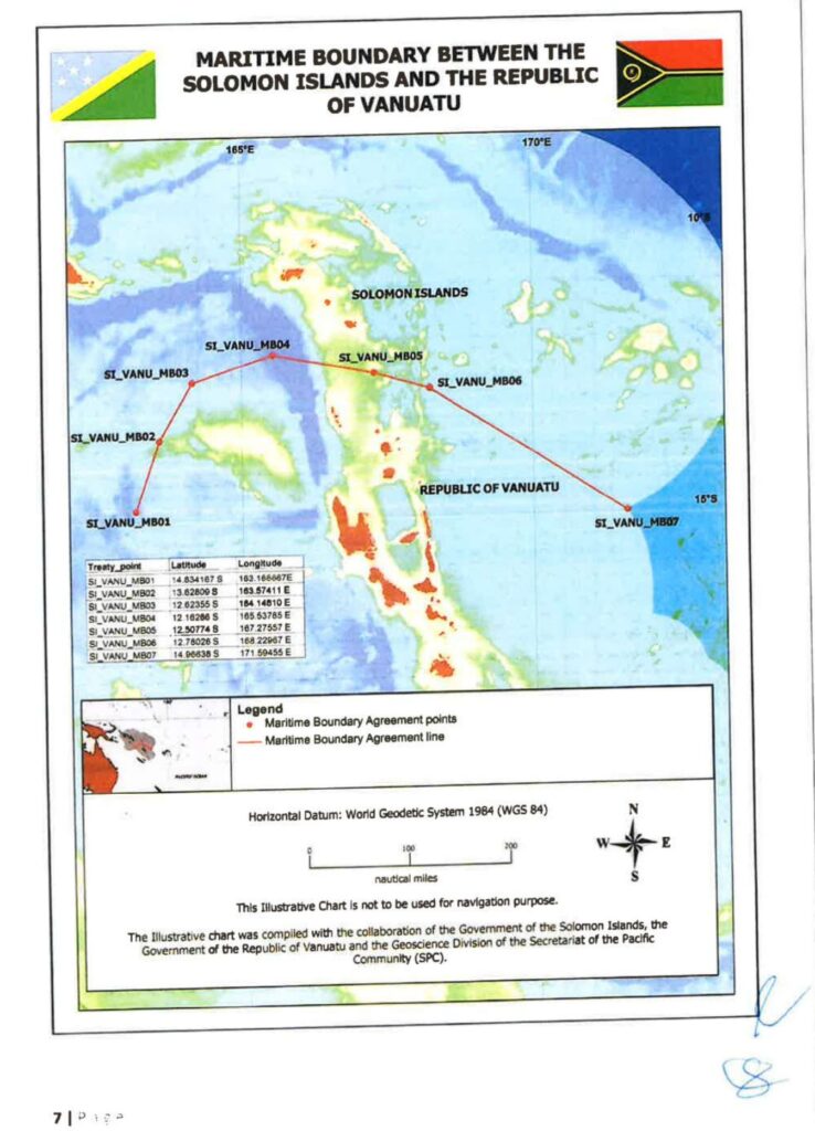
- Document: Treaty Between the Solomon Islands and Vanuatu Concerning Maritime Boundaries, 7 October 2016 (English)
- Alternative Document language: French version
(English) Treaty between Papua New Guinea and Solomon Islands Concerning Sovereignty, Maritime and Seabed Boundaries between the Two Countries, and Cooperation on Related Matters, 25 January 1989
- Summary
This legal document contains the English version of the Treaty between Papua New Guinea and Solomon Islands Concerning Sovereignty, Maritime and Seabed Boundaries between the Two Countries, and Cooperation on Related Matters, signed on 25 January 1989.
The maritime boundary is described in Article 2, and specific coordinates constituting the line are listed in Annex I of the Treaty.
Notably, Article 7 of the Treaty establishes "Special Areas" Within the North Solomons Province of Papua New Guinea and the Western and Malaita Provinces of Solomon Islands to "acknowledge and protect the traditional way of life and livelihood of the traditional inhabitants living in the special areas".
(English version) Agreement between Solomon Islands and Australia establishing certain sea and seabed boundaries, 13 September 1988
- Summary
This legal document contains the English versions of the Agreement between Solomon Islands and Australia establishing certain sea and seabed boundaries, signed on 13 September 1988.
The coordinates of the three basepoints constituting the EEZ and Continental shelf boundary between Australian Reefs in the Coral Sea and Solomon Islands Reefs are listed in Article 1.1 of the Agreement.