The Philippines' A Partial Submission of Data and Information on the Outer Limits of the Continental Shelf of the Republic of the Philippines in respect of the Benham Rise (2 July 2024)
- Summary
This legal document contains the Executive Summary of the Philippines's Partial Submission of Data and Information on the Outer Limits of the Continental Shelf of the Republic of the Philippines beyond 200 Nautical Miles in the Benham Rise Region eastern to Luzon Island, submitted on 2 July 2012.
Notably, Section 3.3 clarifies that this Partial Submission "does not in any manner prejudice the position of any coastal state.", but seeks to "to avoid creating or provoking maritime boundary disputes where there are none, or exacerbating them where they may exist." Section 6 of this document includes the map and coordinates of the outer edge of the continental margin beyond 200 Nautical Miles in the Benham Rise Region eastern to Luzon Island.
Since 16 May 2017, the Benham Rise has been renamed the Philippine Rise, which shall be used in local and international charts and maps.
- Document: Executive Summary of the Philippines's Partial Submission of Data and Information on the Outer Limits of the Continental Shelf of the Republic of the Philippines pursuant to Article 76 (8) of the United Nations Convention on the Law of the Sea
- Related Document:
(English version) The Philippines: Executive Order No. 25 of 16 May 2017 for Changing the Name of "Bentham Rise" to "Philippine Rise" and for Other Purposes
- Summary
This legal document contains Executive Order No. 25 for Changing the Name of "Bentham Rise" to "Philippine Rise" and for Other Purposes, signed by the President of the Philippines Rodrigo Roa Duterte on 16 May 2017.
- Document: Executive Order No. 25 of 16 May 2017 for Changing the Name of "Bentham Rise" to "Philippine Rise" and for Other Purposes (English version, adopted from UN Treaty Series).
- Additional document: Circular Communication from The Secretary-General of the United Nations regarding the Philippines Rise name change
- Related Articles:
Memorandum Circula No. 94 on 17 March 2016 Creating the National Task Force for the West Philippine Sea
- Summary
This legal document contains the Memorandum Circula No. 94 for Creating the National Task Force for the West Philippine Sea,(NTF-WPS) established on 17 March 2016. The document consists of 7 Sections. Creation of the National task Force for the West Philippines Sea & Representatives/Chairperson Members. Section 2: Functions of the NTF-WPS. Section 3: Creation of Area-level and tactical-level task Force. Section 4: Support and Cooperation. Section 5: Separability of provisions' validity. Section 6: Repeal any regulations, rules, and proclamations that are inconsistent with any provision of this Circula. Section 7: Effectivity: The Circula takes effect immediately
Map and Deposit of Amended Chart and Relevant Information on the Philippine Rise
- Summary
This legal document contains the Deposit of Amended Chart and Relevant Information on Philippine Rise
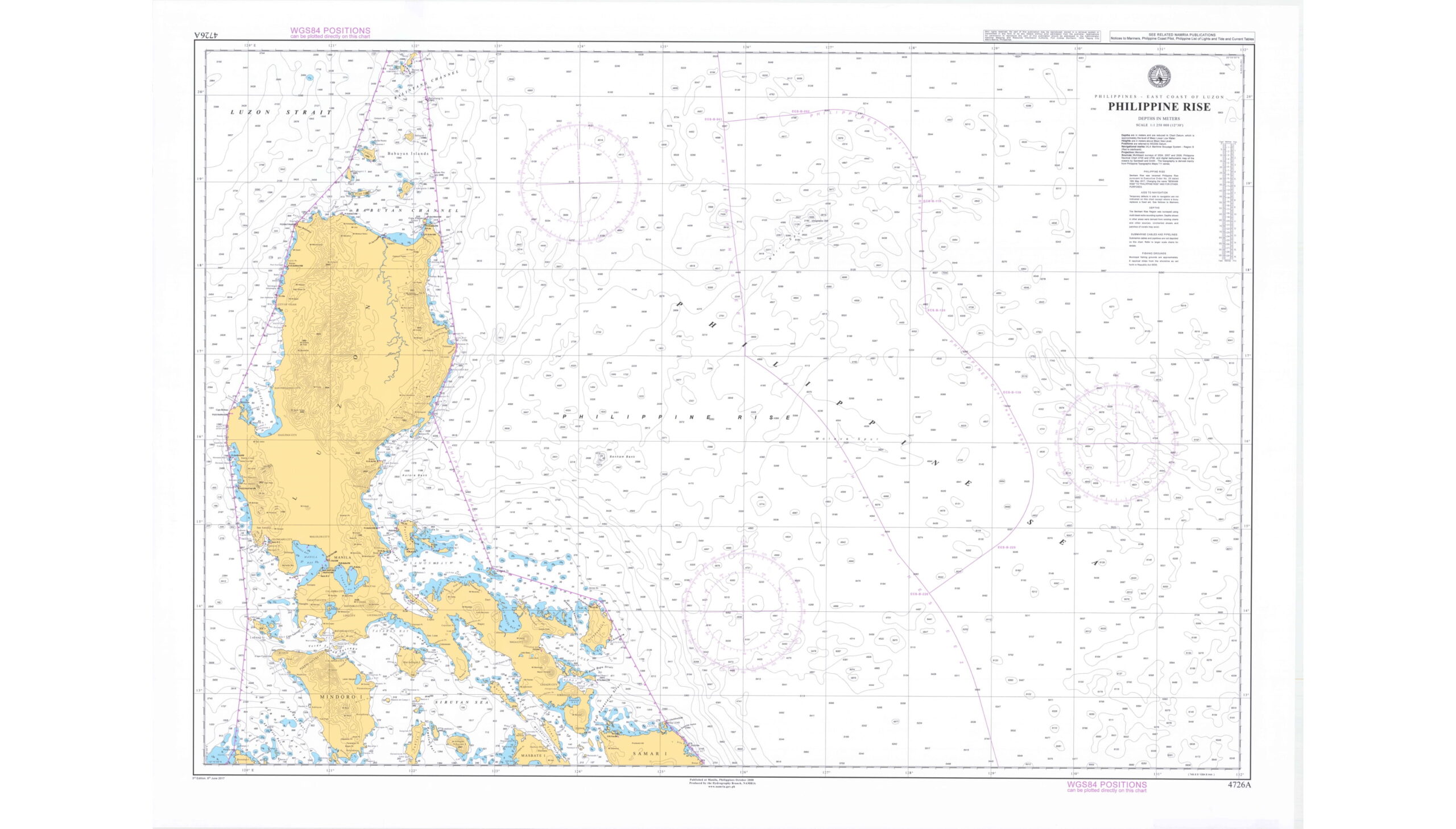
- Document: Deposit of Amended Chart and Relevant Information on the Philippine Rise
- Additional document: Circular Communication from The Secretary-General of the United Nations regarding the Philippines Rise name change
- Related Articles:
Administrative Order No. 29 on 5 September 2012 Naming the West Philippine Sea of the Republic of the Philippines and for Other Purposes
- Summary
This legal document contains Administrative Order No. 29 for Naming the West Philippine Sea of the Republic of the Philippines and for Other Purposes, signed by the President of the Philippines Benigno S. Aquino III on 5 September 2012. The Administrative Order consists of 11 Sections. The maritime area that would be named the West Philippines Sea covers those on the western side of the Philippines archipelago, specifically the Luzon Sea as well as the waters around, within, and adjacent to the Kalayaan Island Group and Bajo De Masinloc, also known as Scarborough Shoal.
The Philippines' Partial Submission to the CLCS on Data and Information on the Outer Limit of the Continental Shelf in the West Palawan Region (14 June 2024)
- Summary
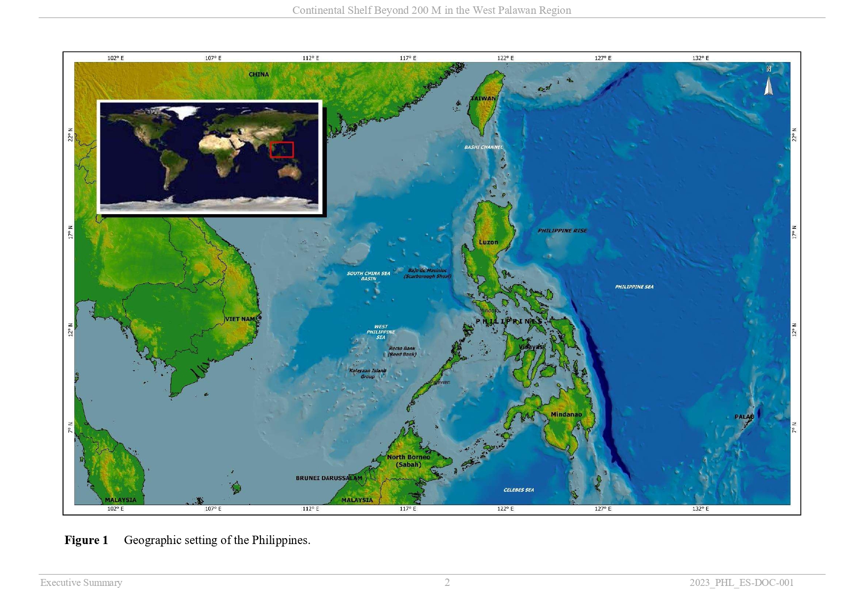
This legal document contains the Executive Summary of the Philippines's Partial Submission of Data and Information on the Outer Limits of the Continental Shelf of the Republic of the Philippines beyond 200 Nautical Miles in the West Palawan Region, submitted on 14 June 2024.
The West Palawan Region mentioned in the Document is visualized as in the below image.
 Document: (Executive Summary) The Philippines' Partial Submission to the CLCS on Data and Information on the Outer Limit of the Continental Shelf in the West Palawan Region (14 June 2024)
- Related Documents: (Executive Summary) the Philippines's Partial Submission of Data and Information on the Outer Limits of the Continental Shelf in the Benham Rise (Philippine Rise) Region Eastern to Luzon Island
(English version) The Philippines: Presidential Decree No. 1599 of 11 June 1978 Establishing an Exclusive Economic Zone and for other Purposes
- Summary
This legal document contains the Presidential Decree No. 1599 of the Philippines on 11 June 1978 Establishing an Exclusive Economic Zone and for Other Purposes, published in the Gazette on 11 June 1978. This Decree No.1599 consists of 6 Sections. Section 1: The declaration of the establishment of the Exclusive Economic Zone (EEZ) of the Philippines. Section 2: Sovereign rights and other rights of the Republic of the Philippines in the said EEZ. Section 3: Prohibited maritime operations of foreign individuals, organizations, vessels, states within the said EEZ without a license granted from the authority of the Philippines. Section 4: Rights of other states in the EEZ of the Philippines. Section 5: Provisions relating to the authorization of government office/agencies to enforce the Decree and Penalties for the violation of the Decree. Section 6: Declaration that this Decree No.1599 shall take effect 30 days after the publication in the Gazette.
- Document: Presidential Decree No. 1599 of the Philippines on 11 June 1978 Establishing an Exclusive Economic Zone and for Other Purposes (English version, adopted from UN Treaty Series)
(English version) The Philippines: Presidential Decree No. 1596 of 11 June 1978 Declaring Certain Area Part of the Philippines Territory and Providing for their Government and Administration
- Summary
This legal document contains the Presidential Decree No. 1596 of the Philippines on 11 June 1978 Declaring Certain Area Part of the Philippine Territory and Providing for their Government and Administration. This decree was signed by President of the Philippines Ferdinand E. Marcos on 11 June 1978 and took effect immediately as provided in Section 3.
This Decree No. 1596 was established to specify the coordinates of and to name the cluster of island and islet as "Kalayaan Island Group" (KIG). This Decree clarifies that the KIG is part of the continental margin of the Philippines, vital to the security of the security and economy of the Philippines, and not legally claimed to be a part of any states or nations. Therefore, the KIG and its sea-bed, sub-soil, continental margin, and space shall be subject to the sovereignty of the Philippines, and be constituted as a separate municipality of the Province of Palawan.
(English version) The Philippines: Presidential Proclamation No. 370 of 20 March 1968 Declaring as Subject to the Jurisdiction and Control of all Mineral and other Resources in the Continental Shelf
- Summary
This legal document contains the English version of the Presidential Proclamation No. 370 of 20 March 1968 Declaring as Subject to the Jurisdiction and Control of all Mineral and other Resources in the Continental Shelf, proclaimed by President Ferdinand E. Marcos. The proclamation covers the natural resources in the sea bed and subsoil of the continental shelf but outside of its territorial sea. The waters above the submarine areas such as high seas and that of the airspace are not affected by this proclamation.
- Document: The Philippines Presidential Proclamation No. 370 of 20 March 1968 Declaring as Subject to the Jurisdiction and Control of all Mineral and other Resources in the Continental Shelf (English version, adopted from UN Treaty Series)