(English version) Agreement between Australia and Indonesia Establishing Certain Seabed Boundaries in the Area of The Timor and Arafura Seas on 9 October 1972, Supplementary to the Agreement of 18 May 1971
Country: Indonesia, Australia
Sea: Timor Sea, Arafura Sea
Scope: Bilateral
Document Language: English
*Note: This Agreement was signed in 1972 when Papua New Guinea was still an Australian-administered United Nations trust territory (hence called “Trust territory of Papua New Guinea in the Agreement). It was on 15 September 1975 that established an official independent nation of Papua New Guinea.
- Summary
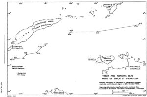
This legal document contains the English version of the Agreement between the Government of the Common Wealth of Australia and the Government of the Republic Of Indonesia Establishing Certain Seabed Boundaries in the Area of The Timor and Arafura Seas, signed on 9 October 1972. First, This 1972 Agreement is considered supplementary to the Agreement of 18 May 1971, specifically Article 2. The seabed boundary between the two parties in this 1972 Agreement extends westward from point A12, which was the most western point of the agreed boundary in the 1971 Agreement, to point A13, A14, A15, and A16. The specific coordinates of those points are provided in Article 1,
Second, Article 2 of this 1972 Agreement also establishes another seabed boundary between the two countries in the area south of the Roti and Timor Islands. The boundary consists of straight lines connecting points whose coordinates are specified in the same Article.
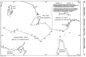
Visualizing Map: Left: 1972 Agreement’s Map; Right: 1971 Agreement’s Map
- Document: Agreement between Australia and Indonesia Establishing Certain Seabed Boundaries in the Area of The Timor and Arafura Seas on 9 October 1972, Supplementary to the Agreement of 18 May 1971 (English version, adopted from UN Treaty Series)
- Related Document:
- Alternative Language Document: