(English & Tokelauan version) Agreement between New Zealand and Kiribati concerning the delimitation of the maritime boundaries between Tokelau and Kiribati, 29 August 2012
- Summary
This legal document contains the English and Tokelauan version of the Agreement between New Zealand and Kiribati concerning the delimitation of the maritime boundaries between Tokelau (New Zealand) and Kiribati, signed on 29 August 2012.
As stated in Article 1, the boundary line is formed using the equidistant method, based on the distance between the nearest territorial sea baseline of the two states. Specific coordinates constituting the boundary line are listed in Article 2.1. Article 3 states how the continental shelf boundary, in case where it extends beyond 200 nm of the EEZ, shall be completed.
(English, French & Tokelauan version) Agreement between France and New Zealand concerning the delimitation of the maritime boundaries between Wallis and Futuna and Tokelau, 30 June 2003
- Summary
This legal document contains the English, French, and Tokelauan version of the Agreement between France and New Zealand concerning the delimitation of the maritime boundaries between the French Republic off the Territory of Wallis & Futuna, and Tokelau (New Zealand), signed on 30 June 2003. Specific coordinates constituting the maritime boundary are listed in Article 2.2 of the Agreement.
- Document: Agreement between France and New Zealand concerning the delimitation of the maritime boundaries between Wallis and Futuna and Tokelau, 30 June 2003 (English, French, and Tokelauan)
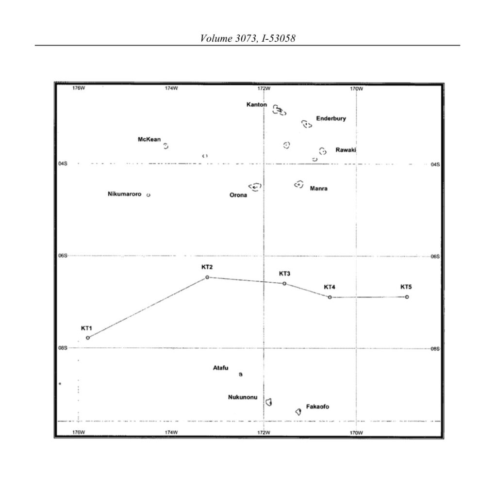
(English & Tokelauan version) Agreement between Cook Islands and New Zealand concerning the Delimitation of Maritime Boundaries between the Cook Islands and Tokelau 8 April 2010
- Summary
This legal document contains the English and Tokelauan version of the Agreement between the Cook Islands and New Zealand concerning the Delimitation of Maritime Boundaries between the Cook Islands and Tokelau, signed on 8 April 2010.
Tokelau (Tokelau Islands) is a dependent territory of New Zealand that is constituted by tropical coral atolls.
Article 1 of the Agreement specifies the use of the equidistant method in maritime boundary demarcation.
Article 2 provides the specific coordinates constituting the maritime boundary.
Article 3 clarifies that shall there be a continental shelf boundary between the Cook Islands and Tokelau that locates beyond both's EEZ and thus necessitates the extension of the boundary stated in Article 2, such boundary line shall be extended in accordance with international laws.

(English version) Agreement between Japan and South Korea concerning joint development of the southern part of the continental shelf adjacent to the two countries (with map, appendix, agreed minutes and exchanges of notes) on 30 January 1974
- Summary:
This legal document contains the English version of the Agreement between Japan and South Korea concerning joint development of the southern part of the continental shelf adjacent to the two countries (with map, appendix, agreed minutes, and exchanges of notes) on 30 January 1974.
Article 2 of this Agreement establishes that the 'Joint Development Zone" subject to this Agreement shall be an area of continental shelf bounded by straight lines connecting 21 points to enclose the Joint Development Zone. The coordinates of the 21 points are specified in the same Article 2. Under this Agreement, the Joint Development Zone may be divided into 9 Subzones as provided from the thirtheenth to the fifteenth page of the Agreement document. Each of the Subzone will be explored and exploited jointly by concessionaires of both countries. who shall enter into agreements for such joint exploration and exploitation.
Notably, Article 14 of the Agreement establishes the japan-ROK Joint Commission for consultations on matters concerning the implementation of this Agreement. In case any disputes between the two countries regarding the interpretation and implementation of this Agreement cannot be settled via diplomatic channels, the two countries shall refer for decision to an arbitration board composed of three arbitrators. Japan and South Korea each will appoint one arbitrator, and the third arbitrator shall be appointed by the two chosen arbitrators, provided that the third arbitrator shall not be a national from neither Japan nor South Korea.
- Document: Agreement between Japan and South Korea concerning joint development of the southern part of the continental shelf adjacent to the two countries (with map, appendix, agreed minutes and exchanges of notes) on 30 January 1974 (English version)
- Related document: Agreement between Japan and South Korea concerning the establishment of boundary in the northern part of the continental shelf adjacent to the two countries (with map and agreed minutes) on 30 January 1974 (English version)

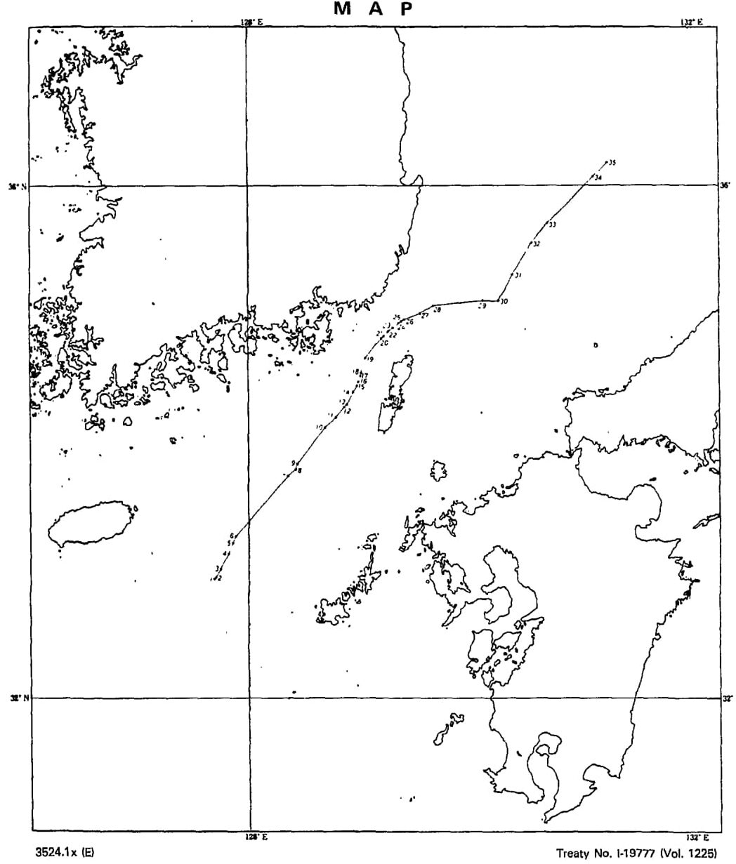
(English version) Agreement between Japan and South Korea concerning the establishment of boundary in the northern part of the continental shelf adjacent to the two countries (with map and agreed minutes) on 30 January 1974
- Summary:
This legal document contains the English version of the Agreement between Japan and South Korea concerning the establishment of boundary in the northern part of the continental shelf adjacent to the two countries (with map and agreed minutes) signed on 30 January 1974. As provided by Article 3, apart from continental shelves delimitation, this Agreement shall not affect the legal status of the superjacent waters around and airspace above the continental shelves area subjected to this Agreement.
Article 1 provides the coordinates of 26 points constituting the boundary line between that part of the continental shelf appertaining to Japan and that part of the continental shelf appertaining to the Republic of Korea in the northern part of the continental shelf adjacent to the two countries.
Notably, Article 2 clarifies that in case Japan and South Korea are unable to agree on a manner to 'most effectively exploit' any geological structure or field of mineral deposit beneath the seabed that extends across the boundary line, the dispute shall be referred to a third party arbitration at the request of either party. The decision of that arbitration shall be binding on both Japan and South Korea.
- Document: Agreement between Japan and South Korea concerning the establishment of boundary in the northern part of the continental shelf adjacent to the two countries (with map and agreed minutes) signed on 30 January 1974 (English version)
- Related document: Agreement between Japan and South Korea concerning joint development of the southern part of the continental shelf adjacent to the two countries (with map, appendix, agreed minutes, and exchanges of notes) on 30 January 1974 (English version)
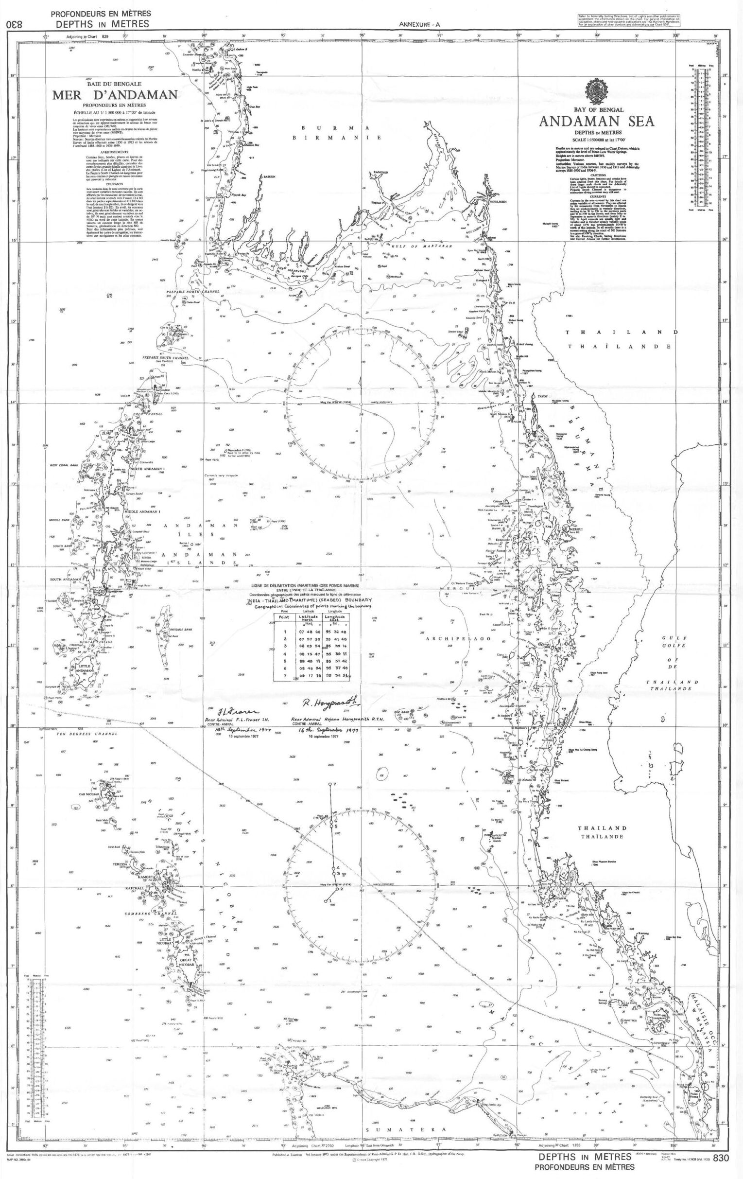
(Hindi and Burmese versions) Agreement between India and Myanmar on the delimitation of the maritime boundary in the Andaman Sea, in the Coco Channel and in the Bay of Bengal on 23 December 1986
- Summary:
This legal document contains the English version of the Agreement between India and Myanmar on the delimitation of the maritime boundary in the Andaman Sea, in the Coco Channel, and in the Bay of Bengal on 23 December 1986.
Article 1 of the Agreement lists the specific coordinates of 14 points (points 1 to 14) constituting the maritime boundary between Burma (Myanmar) and India in the Andaman Sea and in the Coco Channel. Article 2 of the Agreement states the coordinates of points 14, 15, and 16, whose connecting lines shall constitute the maritime boundary between the two countries in the Bay of Bengal. The extension of the maritime boundary between the two countries in the Bay of Bengal shall be done subsequently.
Notably, the final paragraph of Article 1 clarifies that the maritime boundary between India and Burma (Myanmar) will be extended from point 1 up to the trijunction point between India, Myanmar, and Thailand, which would be concluded in 1993, 7 years later after this Agreement.
- Document: Agreement between India and Myanmar on the delimitation of the maritime boundary in the Andaman Sea, in the Coco Channel, and in the Bay of Bengal on 23 December 1986 (Hindi and Burmese version)
- Alternative document languages: English version
- Related document: Agreement between India. Myanmar, and Thailand Concerning the Determination of the Trijunction Point between the three Countries in the Andaman Sea on 27 October 1993 (English version)


(English version) Agreement between India and Myanmar on the delimitation of the maritime boundary in the Andaman Sea, in the Coco Channel and in the Bay of Bengal on 23 December 1986
- Summary:
This legal document contains the English version of the Agreement between India and Myanmar on the delimitation of the maritime boundary in the Andaman Sea, in the Coco Channel, and in the Bay of Bengal on 23 December 1986.
Article 1 of the Agreement lists the specific coordinates of 14 points (points 1 to 14) constituting the maritime boundary between Burma (Myanmar) and India in the Andaman Sea and in the Coco Channel. Article 2 of the Agreement states the coordinates of points 14, 15, and 16, whose connecting lines shall constitute the maritime boundary between the two countries in the Bay of Bengal. The extension of the maritime boundary between the two countries in the Bay of Bengal shall be done subsequently.
Notably, the final paragraph of Article 1 clarifies that the maritime boundary between India and Burma (Myanmar) will be extended from point 1 up to the trijunction point between India, Myanmar, and Thailand, which would be concluded in 1993, 7 years later after this Agreement.
- Document: Agreement between India and Myanmar on the delimitation of the maritime boundary in the Andaman Sea, in the Coco Channel, and in the Bay of Bengal on 23 December 1986 (English version)
- Alternative document languages: Hindi and Burmese version
- Related document: Agreement between India. Myanmar, and Thailand Concerning the Determination of the Trijunction Point between the three Countries in the Andaman Sea on 27 October 1993 (English version)
(English version) Agreement between Burma (Myanmar) and Thailand on the delimitation of the maritime boundary between the two countries in the Andaman Sea on 25 July 1980
- Summary:
This legal document contains the English version of the Agreement between Burma (Myanmar) and Thailand on the delimitation of the maritime boundary between the two countries in the Andaman Sea signed on 25 July 1980. Article 1.1 of the Agreement specifies the coordinates of the 9 points constituting the maritime boundary between the two state parties under the equidistance basis. Article 1.2 specifies that the segment of the maritime boundary comprising the lines connecting points 1,2,3,4, and 5 shall indicate the territorial sea boundary between the two countries. Article 1.3 states that the segment connecting point 5 through points 6.7.8. and 9 shall constitute the continental shelves boundary, and Exclusive Economic Zone (EEZ) between the two countries if Thailand establishes her EEZ (This Agreement was signed before the open-signing day of the UNCLOS III in 1982.)
Article 1.4 clarifies that the extension of the bilateral maritime boundary shall extend in the direction of and up to the maritime boundary trijunction point between Thailand, Burma, and India, which would be concluded in a Trilateral Agreement signed in 1993.
- Document: Agreement between Burma (Myanmar) and Thailand on the delimitation of the maritime boundary between the two countries in the Andaman Sea signed on 25 July 1980 (English version)
- Related document: Agreement between India. Myanmar, and Thailand Concerning the Determination of the Trijunction Point between the three Countries in the Andaman Sea on 27 October 1993 (English version)

(Hindi & Thai version) Agreement between Thailand and India on the delimitation of sea-bed boundary between the two countries in the Andaman Sea on 22 June 1978
- Summary:
This legal document contains the Hindi and Thai version of the Agreement between Thailand and India on the delimitation of the sea-bed boundary between the two countries in the Andaman Sea on 22 June 1978 signed on 22 June 1978. Notably, Article 1 of the Agreement specifies the coordinates of the 7 points constituting the seabed boundary between the two state parties.
The sea bed boundary between India and Thailand will be extended from the trijunction point agreed between India, Indonesia, and Thailand. in the north-easterly direction to point 1 in this Agreement.
- Document: Agreement between Thailand and India on the delimitation of the sea-bed boundary between the two countries in the Andaman Sea on 22 June 1978 signed on 22 June 1978 (Hindi & Thai version)
- Alternative document languages: English version
- Related document: Agreement between India. Indonesia, and Thailand Concerning the Determination of the Trijunction Point and the Delimitation of the Related Boundaries of the three Countries in the Andaman Sea on 22 June 1978 (English version)
(English version) Agreement between Thailand and India on the delimitation of sea-bed boundary between the two countries in the Andaman Sea on 22 June 1978
- Summary:
This legal document contains the English version of the Agreement between Thailand and India on the delimitation of the sea-bed boundary between the two countries in the Andaman Sea on 22 June 1978 signed on 22 June 1978. Notably, Article 1 of the Agreement specifies the coordinates of the 7 points constituting the seabed boundary between the two state parties.
The sea bed boundary between India and Thailand will be extended from the trijunction point agreed between India, Indonesia, and Thailand. in the north-easterly direction to point 1 in this Agreement.
- Document: Agreement between Thailand and India on the delimitation of the sea-bed boundary between the two countries in the Andaman Sea on 22 June 1978 signed on 22 June 1978 (English version)
- Alternative document languages: Hindi and Thai versions
- Related document: Agreement between India. Indonesia, and Thailand Concerning the Determination of the Trijunction Point and the Delimitation of the Related Boundaries of the three Countries in the Andaman Sea on 22 June 1978 (English version)