(Unofficial English translation) Agreement on Fishery Cooperation in the Tonkin Gulf between P.R of China and Vietnam on 25 December 2000
The document attached to this article is an unofficial English translation of the Agreement, which was originally provided in 2 official versions of Chinese and Vietnamese only. The contents and wordings of this English version were checked vis a vis the official Vietnamese version by the editor who is capable of both English and Vietnamese.
- Summary
This legal document contains the English version of the Agreement on Fishery Cooperation in the Tonkin Gulf between the Government of the People's Republic of China and the Government of the Socialist Republic of Vietnam, signed on 25 December 2000. Article 3 of this Agreement defines a Common Fishery Zone, which extends 30.5 nautical miles into the exclusive economic zones of the two countries from the demarcation line determined in the Delimitation Agreement on Tonkin Gulf, southerly to the closing line of the Tonkin Gulf, and northerly to the 20" N Latitude. The coordinates of points constituting the Common Fishery Zone are specified in Article 3 of the Agreement. Article 13 makes provision for the establishment of the Sino-Vietnamese Joint Committee for Fishery in the Tonkin Gulf in order to implement the Agreement, which shall consist of two representatives respectively appointed by both Governments and several committee members. The rights and responsibilities of both contracting parties and their vessels for the purpose of fishing are stated in the Agreement, which shall be monitored by respective Governments and the Joint Committee. Article 12 also provides a buffer zone starting from the Beilun estuary (point 1 of Sino-Vietnamese delimitation line in the Delimitation Agreement on Tonkin Gulf), whose coordinates are specified in Article 12.
Finally, Article 22.2 clarifies that this Agreement shall enter into force after both parties carried out necessary domestic legal procedures, become valid for a period of 12 years, and extend for another 3 years afterward automatically. The extension of the Agreement after that fifteen-year period shall be negotiated by both Parties. However, after the Agreement entered into force on 30 June 2004-2019, the two countries only extended it for one year until 30 June 2020. After its expiration in 2020, there has been no announcement of new negotiation for the extension of the Agreement.
- Document: Agreement on Fishery Cooperation in the Tonkin Gulf between the Government of the People's Republic of China and the Government of the Socialist Republic of Vietnam on 25 December 2000 (English version)
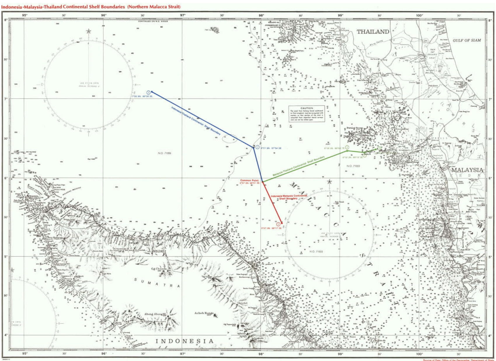
(English version) Agreement between Indonesia, Malaysia, and Thailand Relating to the Delimitation of the Continental Shelf Boundaries in the Northern Part of the Strait of Malacca on 21 December 1971
- Summary
This legal document contains the English version of the Agreement between the Government of the Republic of Indonesia, The Government of Malaysia, and the Government of the Kingdom of Thailand Relating to the Delimitation of the Continental Shelf Boundaries in the Northern Part of the Strait of Malacca signed on 21 December 1971. This Agreement concludes a common tripoint as a starting point for the continental shelves boundary between any two of the three parties. The coordinates of the tripoint are Latitude 5° 57.0' N Longitude 98° 01.5' E.
Article 1 provides that the continental shelves boundary between any two of the three parties shall extend to the tripoint, with the tripoint becoming the starting point of each boundary.
(English version) Agreement relating to the Delimitation of a Continental Shelf Boundary between Indonesia and Thailand in the Northern Part of the Straits of Malacca and in the Andaman Sea on 17 December 1971
- Summary
This legal document contains the English version of the Agreement relating to the Delimitation of a Continental Shelf Boundary between Indonesia and Thailand in the Northern Part of the Straits of Malacca and in the Andaman Sea, signed on 17 December 1971. The continental shelves boundary between the two countries in the said area is a straight line connected by 2 points called point 1 and point 2, whose coordinates are specified in the document.
Notably, Article I.2 states that the continental shelves boundary between the two countries in the Northern part of the Strait of Malacca shall be completed by extending from point 1 eastward/southeastward to a "common tripoint" between Indonesia, Malaysian, and Thailand. That tripoint would be established four days later on 21 December 1971 in a Tripartite Agreement between the three countries.
- Document: Agreement relating to the Delimitation of a Continental Shelf Boundary between Indonesia and Thailand in the Northern Part of the Straits of Malacca and in the Andaman Sea on 17 December 1971 (English version, adopted from UN Treaty Series)
(English version) Treaty between the Indonesia and Malaysia relating the Delimitation of the Territorial Seas of the Two Countries in the Straits of Malacca on 17 Mar 1970
- Summary
This legal document contains the English version of the Treaty between the Republic of Indonesia and Malaysia relating to the Delimitation of the Territorial Seas of the Two Countries in the narrow part of the Straits of Malacca signed on 17 Mar 1970. The coordinates determining the "narrow part" of the Strait of Malacca are stated in the preamble of the Treaty. The agreed Territorial seas boundary between the two countries in the said area is a median line between their respective baselines (not archipelagic baseline yet), which constitutes straight lines connecting 8 points. The coordinates of those 8 points are provided in Article 1.2.a of the Treaty.
Notably, besides point 1 (the starting point) and point 6, all other points' coordinates coincide with those of the continental shelves boundary between the two countries agreed in October 1969. For point 6, it is beyond the 12-nautical mile territorial sea baseline of Malaysia, and thus the Malaysian territorial sea boundary goes straight from point 5 to 7, while that of Indonesia goes through all points normally.
- Document: Treaty between the Republic of Indonesia and Malaysia relating to the Delimitation of the Territorial Seas of the Two Countries in the narrow part of the Straits of Malacca on 17 Mar 1970 (English version, adopted from JUS MUNDI )
(English version) Agreement between Malaysia and Indonesia on the Delimitation of the Continental Shelves between the two Countries on 27 October 1969
- Summary
This legal document contains the English version of the Agreement between the Government of Malaysia and the Government of Indonesia on the delimitation of the continental shelves between the two countries signed on 27 October 1969. The boundary agreed shall delimit the continental shelves of the two countries in the Straits of Malacca and in the South China Sea. The boundary constitutes straight lines connecting points whose coordinates are specified in the document. Chart A, B, and C show the coordinates of points of the boundary in the Strait of Malacca, in the western side - off the east coast of West Malaysia, and in the eastern side - off the coast of Sarawak, respectively.
This Agreement facilitates the exploitation of geological petroleum or natural gas structures extending across the straight lines between Indonesia and Malaysia. Notably, Article 2 clarifies that "This Agreement shall not in any way affect any future agreement which may be entered into between the two Governments relating to the delimitation of the territorial sea boundaries between the two countries." Nonetheless, the agreement on the boundary of the territorial seas between the two countries took place half a year later in Kuala Lumpur.
(English version) Treaty between Indonesia and Singapore relating to the Delimitation of the Territorial Seas of the two Countries in the Eastern Part of the Strait of Singapore on 3 September 2014
- Summary:
This legal document contains the English version of the Treaty between the Republic of Indonesia and the Republic of Singapore relating to the delimitation of the territorial seas of the two countries in the eastern part of the Strait of Singapore signed on 3 September 2014. Specifically, the boundary of the territorial seas of both parties in the Strait of Singapore is extended eastward from "point 6", which was the eastern terminus of the boundary agreed in the 2009 Treaty, which was extended to the western segment of "point 1" of the original boundary agreed in the 1973 Treaty. The boundary agreed in this 2014 Treaty constitutes straight points connecting three points called point 6, point 7, and point 8, eastward from point 6 agreed in 1973.
In case the territorial sea boundary of Indonesia and Singapore is to be extended eastward within the Strait of Singapore, it shall be negotiated within a trilateral agreement between Indonesia, Malaysia, and Singapore, minding the archipelagic baseline of all parties.
- Document: Treaty between the Republic of Indonesia and the Republic of Singapore relating to the delimitation of the territorial seas of the two countries in the eastern part of the Strait of Singapore on 3 September 2014 (English version, adopted from UN Treaty Series)
(English version) Treaty between Indonesia Singapore relating to the Delimitation of the Territorial Seas of the two Countries in the Western Part of the Strait of Singapore on 10 March 2009
- Summary
This legal document contains the English version of the Treaty between the Republic of Indonesia and the Republic of Singapore relating to the delimitation of the territorial seas of the two countries in the western part of the Strait of Singapore signed on 10 March 2009. Specifically, the boundary of the territorial seas of both parties in the Strait of Singapore is extended westward from "point 1", which was the western terminus of the boundary agreed in the 1973 Treaty. The boundary agreed in this 2009 Treaty constitutes straight points connecting three points called 1A, 1B, and 1C, namely westward.
Notably, point 1A (1° 11' 17.4"N - 103° 39' 38.5"E) is measured to locate in between Indonesia's Pulau Nipah (1° 8' 49.9992"N - 103° 39' 24.9984"E) and Singapore's Sultan Shoal (1°14′24″N - 103°38′53″E). The use of Pulau Nipah shows that Indonesia's archipelagic baseline which was legally conceptualized along with the concept of ärchipelagic water" in Indonesia's Act No.6 in 1996 and in UNCLOS in 1985. Finally, point 1C, which is the western terminus of the boundary agreed in this 2009 Treaty is not the adjacent point between Indonesia's, Singapore's, and Malaysia's territorial sea boundary. The extension of the territorial sea boundary of both countries in the Strait of Singapore western to point 1C shall be negotiated by Indonesia, Malaysia, and Singapore.
- Document: Treaty between the Republic of Indonesia and the Republic of Singapore relating to the delimitation of the territorial seas of the two countries in the western part of the Strait of Singapore on 10 March 2009 (English version, adopted from UN Treaty Series)
(English version) Treaty between Indonesia and Singapore relating to the Delimitation of the Territorial Seas of the two Countries in the Strait of Singapore on 25 May 1973
- Summary
This legal document contains the English version of the Treaty between the Republic of Indonesia and the Republic of Singapore relating to the delimitation of the territorial seas of the two countries in the Strait of Singapore signed on 25 May 1973. Noting that the coasts of the two parties are opposite to each other in the Strait of Singapore, the Treaty was concluded with the establishment of a partial territorial sea boundary in the Strait of Singapore. The boundary is constituted by straight lines connecting 6 agreed points, whose coordinates are clarified in the document. Notably, "point 2" of the six points constituting the boundary of the territorial seas of the two countries is located in Indonesia's internal water, and on the line which would be called Indonesia's archipelagic baseline.
The boundary of the territorial seas of the two countries in the Strait of Singapore in this 1973 Treaty would be extended to the western segment of "point 1" in 2009 and to the eastern segment of "point 6" in 2014.
- Document: Treaty between Indonesia and Singapore relating to the Delimitation of the Territorial Seas of the Two Countries in the Strait of Singapore on 25 May 1973 (adopted from UN Treaty Series).
(English version) Treaty between Thailand and Malaysia relating to the Delimitation of the Territorial Seas of the Two Countries on 24 October 1979
- Summary
This legal document contains the English version of the Treaty between Thailand and Malaysia relating to the Delimitation of the Territorial Seas of the Two Countries signed on 24 October 1979. There are two boundaries agreed in this Treaty, one for both parties' territorial sea delimitation in the Gulf of Thailand, and the other in the Malacca Strait between the "Butang Group" and Pulau Langkawi Island. The coordinates of the points forming the two territorial sea boundaries are specified in the Treaty.
- Document: Treaty between Thailand and Malaysia relating to the Delimitation of the Territorial Seas of the Two Countries on 24 October 1979 (English version, adopted from UN Treaty Series).
(English version) Memorandum of Understanding between Thailand and Malaysia on the Delimitation of the Continental Shelf Boundary between the Two Countries in the Gulf of Thailand on 24 October 1979
- Summary
This legal document contains the English version of the Memorandum of Understanding (MoU) between the Kingdom of Thailand and Malaysia on the Delimitation of the Continental Shelf Boundary between the Two Countries in the Gulf of Thailand signed on 24 October 1979. In this MoU, the two parties establish a partial but official boundary of their continental shelves in the Gulf of Thailand.
Notably, the agreed continental shelf boundary between Thailand and Malaysia in the Gulf of Thailand does not extend to the joint developmental area established in another MoU of both parties signed in February 1979. Therefore, Article 3 clarifies that both parties "shall continue negotiations to complete the delimitation of the continental shelf boundary of the two Countries in the Gulf of Thailand." Thus, the Malaysia-Thailand Joint Authority over the said joint developmental area shall continue as provided in the February MoU.
- Document: Memorandum of Understanding (MoU) between the Kingdom of Thailand and Malaysia on the Delimitation of the Continental Shelf Boundary between the Two Countries in the Gulf of Thailand on 24 October 1979 (English version, adopted from UN Treaty Series)