(English & French) (Amended version) Treaty between Micronesia and Papua New Guinea concerning Maritime Boundaries and Cooperation on Related Matters, 7 September 2015
- Summary
This legal document contains the English and French versions of the Amended version of the Treaty between Micronesia and Papua New Guinea concerning Maritime Boundaries and Cooperation on Related Matters, signed on 7 September 2015 (the original one was signed on 29 July 1991.)
The Amended version of 2015 only replaces Annex I of the Treaty of 1991 with its Annex I-A, which includes specific coordinates. constituting the maritime boundary between Micronesia and Papua New Guinea. Besides changes in coordinates constituting the maritime boundary (delimitation of EEZ and seabed/continental shelf between the two states), the agreed regulations regarding the exploitation of, protection of, cooperation on, and management of marine living/non-living resources and other agreements are remained as stated in the Treaty of 1991 between the two states.
Treaty between Micronesia and Papua New Guinea concerning Maritime Boundaries and Cooperation on Related Matters, 7 September 2015
- Document: \
- Treaty between Micronesia and Papua New Guinea concerning Maritime Boundaries and Cooperation on Related Matters, 29 July 1991(Annex I of which is replaced by Annex I-A of the 2015 Amendment)
- Amendment to the Treaty, 7 September 2015
(English) Treaty between Papua New Guinea and Solomon Islands Concerning Sovereignty, Maritime and Seabed Boundaries between the Two Countries, and Cooperation on Related Matters, 25 January 1989
- Summary
This legal document contains the English version of the Treaty between Papua New Guinea and Solomon Islands Concerning Sovereignty, Maritime and Seabed Boundaries between the Two Countries, and Cooperation on Related Matters, signed on 25 January 1989.
The maritime boundary is described in Article 2, and specific coordinates constituting the line are listed in Annex I of the Treaty.
Notably, Article 7 of the Treaty establishes "Special Areas" Within the North Solomons Province of Papua New Guinea and the Western and Malaita Provinces of Solomon Islands to "acknowledge and protect the traditional way of life and livelihood of the traditional inhabitants living in the special areas".
(English version) Agreement between Indonesia and Papua New Guinea concerning Maritime Boundaries between the Two Countries and Cooperation on Related Matters on 13 December 1980
*This Agreement was signed between the Government of Papua New Guinea and of Indonesia in 1980 after the former had become an independent nation and ceased to be an UN-trusted territory under Australian administration in 1975.
**In this Agreement, Article 1 clarifies that the term "continental shelf" is used in accordant with International Law, and bears the same meaning as the term "seabed" used in the Seabed Boundary Agreement between Australia and Indonesia in 1971, 1972, 1973 relating to the "seabed" boundary between the two countries, which includes the boundary between Indonesia and Papua New Guinea.
- Summary
This legal document contains the Agreement between the Government of the Republic of Indonesia and the Government of Papua New Guinea concerning Maritime Boundaries between the Two Countries and Cooperation on Related Matters, signed on 13 December 1980.
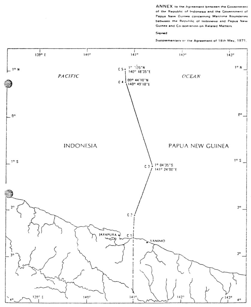
Article 2 of this Agreement, in order to further the continental shelf boundary between Indonesia and Papua New Guinea off the Northern Coast of the two countries from the groundwork (point C1 and C2) provided in Article 4 of the 1971 Australia-Indonesia Seabed Boundary Agreement, establishes point C3, C4, and C5. Their coordinates are specified in the same Article.
Article 4 of this 1980 Agreement also clarifies that the continental shelf boundary (or seabed boundary) between the two countries provided in Article 2 of this 1980 Agreement, in Article 1, 3, and 4 of the 1972 Australia-Indonesia Seabed Boundary Agreement, and in Article 3 of the 1973 Australia-Indonesia Seabed Boundary Agreement shall be both the continental shelf boundary and Exclusive Economic Zone boundary between the two countries.
- Document: Agreement between Indonesia and Papua New Guinea concerning Maritime Boundaries between the Two Countries and Cooperation on Related Matters on 13 December 1980 (English version, adopted from UN Treaty Series)
- Related Document:
- Agreement between Australia and Indonesia Establishing Certain Seabed Boundaries on 18 May 1971
- (English version) 1972 Australia-Indonesia Agreement furthering the west section of the seabed boundary agreed in 1971
- (English version) 1973 Australia-Indonesia Agreement completing the boundary line between Indonesia and Papua New Guinea for the southern coast.
(English version) Agreement between Australia and Indonesia concerning Certain Boundaries between Papua New Guinea and Indonesia on 12 February 1973
*Note: This Agreement was signed in 1973 when Papua New Guinea was still an Australian-administered United Nations trust territory (hence called “Trust territory of Papua New Guinea in the Agreement). It was on 15 September 1975 that established an official independent nation of Papua New Guinea.
- Summary
This legal document contains the English version of the Agreement between Australia and Indonesia concerning Certain Boundaries between Papua New Guinea and Indonesia, signed on 12 February 1973. In this Agreement, there are two boundaries established between Indonesia and Papua New Guinea (Australia-administered). The first one is the boundary on the island of Papua New Guinea, as provided in Article 1 with specific coordinates.
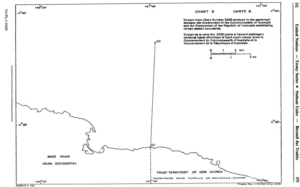
The second boundary is the sea bed boundary in the area of seabed that is adjacent to and appertains to Papua New Guinea and the area that is adjacent to and appertains to Indonesia, in the southern coast of Papua New Guinea/Indonesia on the island of Papua New Guinea. This boundary is provided in Article 3, with the establishment of points B2 and B3, which fulfills the seabed boundary in the same area whose groundwork (point B1) was provided in Article 3 of the 1971 Australia-Indonesia Seabed Agreement.
- Document: Agreement between Australia and Indonesia concerning Certain Boundaries between Papua New Guinea and Indonesia on 12 February 1973 (English version, adopted from UN Treaty Series)
- Alternative Document Language:
- Related Article: 1971 Australia-Indonesia Seabed Boundary Agreement.
(Bahasa Indonesian version) Agreement between Australia and Indonesia Establishing Certain Seabed Boundaries on 18 May 1971
*Note: This Agreement was signed in 1971 when Papua New Guinea was still an Australian-administered United Nations trust territory (hence called “Trust territory of Papua New Guinea in the Agreement). It was on 15 September 1975 that established an official independent nation of Papua New Guinea.
- Summary
This legal document contains the Indonesian version of the Agreement between the Government of the Common Wealth of Australia and the Government of the Republic of Indonesia Establishing Certain Seabed Boundaries, signed on 18 May 1971.
The summary article for this document can be found at that for its English version.
- Document: Agreement between the Government of the Common Wealth of Australia and the Government of the Republic of Indonesia Establishing Certain Seabed Boundaries on 18 May 1971 (English version, adopted from UN Treaty Series)
- Related Articles:
- (Indonesian version) 1972 Australia-Indonesia Agreement furthering the west section of the seabed boundary agreed in 1971
- (Indonesian version) 1973 Australia-Indonesia Agreement completing the boundary line between Indonesia and Papua New Guinea for the southern coast.
- (English version) 1980 Indonesia-Papua New Guinea Agreement establishing Maritime Boundary and furthering the boundary line between the two countries for the northern coast.
(English version) Agreement between Australia and Indonesia Establishing Certain Seabed Boundaries on 18 May 1971
*Note: This Agreement was signed in 1971 when Papua New Guinea was still an Australian-administered United Nations trust territory (hence called "Trust territory of Papua New Guinea in the Agreement). It was on 15 September 1975 that established an official independent nation of Papua New Guinea.
- Summary
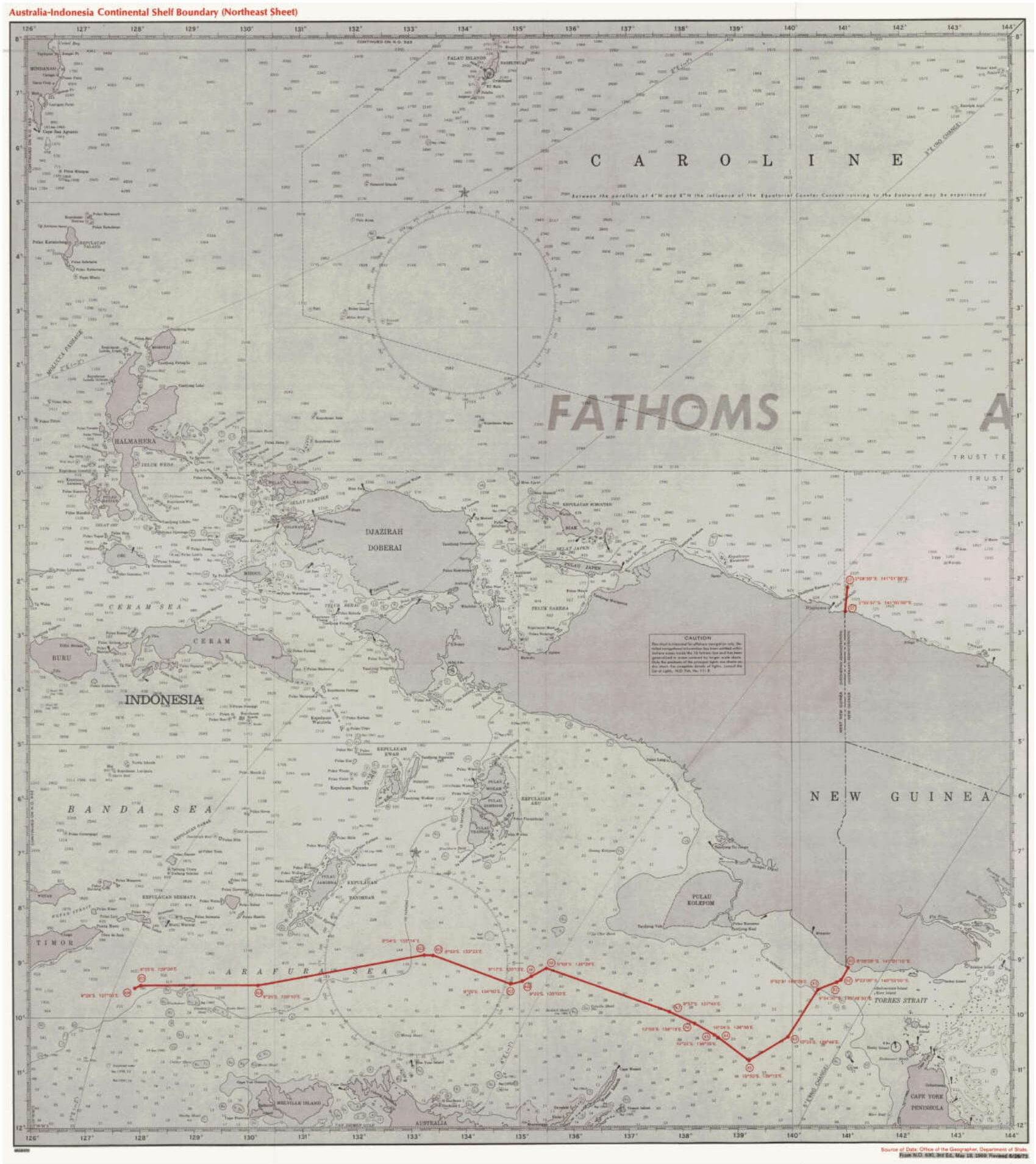
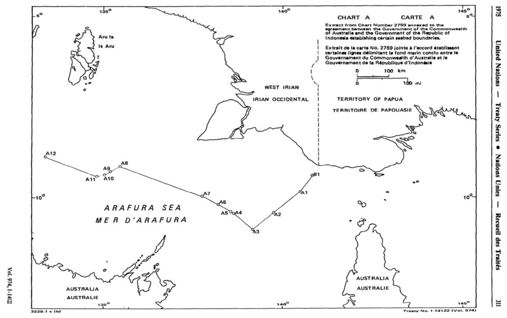
This legal document contains the English version of the Agreement between the Government of the Common Wealth of Australia and the Government of the Republic of Indonesia Establishing Certain Seabed Boundaries, signed on 18 May 1971. The agreed seabed boundary consists of straight lines connecting 12 points (A1 to A12) located between Longitude 133° 23' East of point A12 and Longitude 140° 29' East of point A1. Specific coordinates of the points constituting the agreed seabed boundary are provided in Article 1.
Notably, Article 2 states that the demarcation line of the seabed western to point A12 is not provided in this Agreement, and shall be negotiated in the future, which would be done in another bilateral Agreement in 1972.
The groundwork for seabed delimitation between Indonesia and the Trust Territory of Papua New Guinea is also partly provided in Article 3 (Southern coast of New Guinea adjacent to Indonesia's) and Article 4 (Northern coast of Newguinea adjacent to). The boundary lines for the southern coast of Papua New Guinea adjacent to Indonesia's coast would be completed in another Australia-Indonesia Agreement in 1973. The boundary line for the northern coast of Papua New Guinea adjacent to Indonesia's coast would be done in 1980 between the Government of Indonesia and of Papua New Guinea.
- Document: Agreement between the Government of the Common Wealth of Australia and the Government of the Republic of Indonesia Establishing Certain Seabed Boundaries on 18 May 1971 (English version, adopted from UN Treaty Series)
- Related Articles:
- (English version) 1972 Australia-Indonesia Agreement furthering the west section of the seabed boundary agreed in 1971
- (English version) 1973 Australia-Indonesia Agreement completing the boundary line between Indonesia and Papua New Guinea for the southern coast.
- (English version) 1980 Indonesia-Papua New Guinea Agreement establishing Maritime Boundary and furthering the boundary line between the two countries for the northern coast.
- Alternative Document Language: