(English version) Agreement between Thailand and Vietnam on the Delimitation of the Maritime Boundary between the two Countries in the Gulf of Thailand on 9 August 1997
- Summary
This legal document contains the Agreement between the Government of the Kingdom of Thailand and the Government of the Socialist Republic of Viet Nam on the Delimitation of the Maritime Boundary between the two countries in the Gulf of Thailand on 9 August 1997. This maritime boundary constitutes the boundary for the continental shelves and exclusive economic zone of both contracting parties, which is a line connected by two points C and K. The coordinates of points C and K are stated in the Agreement.
Notably, point C is the northernmost point of the Joint Development Area established by the Memorandum of Understanding between the Kingdom of Thailand and Malaysia on the Establishment of a Joint Authority for the
Exploitation of the Resources of the Seabed in a Defined Area of the Continental Shelf of the Two Countries in the
The Gulf of Thailand. Therefore, Article 2 clarifies that Vietnam and Thailand shall negotiate with Malaysia to settle the tripartite overlapping continental shelf.
- Documents: Agreement between Thailand and Viet Nam on the Delimitation of the Maritime Boundary in the Gulf of Thailand on 9 August 1997 (English version, adopted from UN Treaty Series)
(Vietnamese version) Agreement on the Historical Waters between the Socialist Republic of Vietnam and the People's Republic of Kampuchea
- Summary
This legal document contains the Vietnamese version of the Agreement on the Historical Waters between the Socialist Republic of Vietnam and the People's Republic of Kampuchea signed on 2/18/1979
The summary article of the Agreement can be found in that of its English version.
- Document: Agreement on the Historical Waters between the Socialist Republic of Vietnam and the People's Republic of Kampuchea 2/18/1979 (Vietnamese version)
(Unofficial English translation) Agreement on the Historical Waters between the People's Republic of Kampuchea and Vietnam
*The English version of the Agreement (PDF file) is an unofficial translation, the content of which was checked with the official Vietnamese version by the editor, who is native in Vietnamese. There are no conflicts in the contents and the use of terms between the Vietnamese version and this English version.
- Summary
This legal document contains the Agreement on the Historical Waters between the Socialist Republic of Vietnam and the People's Republic of Kampuchea signed on 18 February 1979. The Historical Waters locate between the coast of Kien Giang province Phu Quoc island to Tho Chu Islands of the Socialist Republic of Vietnam and the coast of Kampot province to Poulo Wai Islands of the People’s Republic of Kampuchea, the specific coordinates of which are stated in the document. The mentioned Historical Waters are put under internal water status due to geographic and historical conditions. According to the document, the patrol, and control activities of, the traditional fishing activities by local people within, and the exploitation of natural resources within the Historical Waters will be conducted by both sides, with bilateral negotiation for resource extraction activities.
Notably, the agreement does not conclude an official maritime boundary between Vietnam and Cambodia within the agreed Historical Waters. Both contracting parties take the Brevie Line as the island divider in the area. The 'point 0", which will be a base point to measure the breadth of the territorial sea of each country, will locate on the line connecting Tho Chu Islands and Poulo Wai Island. This point 0 was officially used as a starting point for the Vietnamese territorial sea's straight baseline in the Statement by the Government Vietnam on the Territorial Sea Baseline in 1982.
- Document: Agreement on the Historical Waters between the Socialist Republic of Vietnam and the People's Republic of Kampuchea 2/18/1979 (unofficial English translation)
(English vesion) Statement on 12 November 1982 of Vietnam on the Territorial Sea Baseline of Viet Nam
- Summary
This legal document contains the Statement on 12 November 1982 by the Government of the Socialist Republic of Viet Nam on the Territorial Sea Baseline of Viet Nam. This legislation was adopted by the Standing Committee of the National Assembly of the Socialist Republic of Viet Nam in implementing the first paragraph of the 1977 Statement on the Territorial Sea, the Contiguous Zone, the Exclusive Economic Zone and the Continental Shelf. In this document, the baseline of Vietnam's territorial sea is connected by straight lines connecting the basepoints, from point 0 as starting point to Con Co Island (middle region of Vietnam). The baseline from Con Co Island up north to the mouth of the Tonkin Gulf will be established following the settlement of the closing line of the Gulf.
Notably, the starting basepoint, point 0, is located "in the sea" on the line linking Tho Chu Archipelago with Poulo Wai Island, which is also "the meeting point of the two baselines for measuring the breadth of the territorial sea of the Socialist Republic of Viet Nam and that of the People's Republic of Kampuchea" (PRK) agreed in 1979. However, there is no clarification of whether point 0 is a low-tide elevation with permanently-above sea level structure installation such as lighthouses or not. While point 0 can be categorized as a special case located in historical water as provided in Article 7.4 of the 1982 UNCLOS and the 1979 Bilateral Agreement mentioned above, its legal status shall be judged based on international recognition. Finally, Article 3 of the Statement claims that "the part of the gulf appertaining to Viet Nam constitutes the historic water. and is subjected to the juridical regime of internal waters". Nonetheless, the Agreement between the People's Republic of China and the Socialist Republic of Viet Nam on the Delimitation of Gulf on Tonkin signed in 2000 implies that the delimited water belongs to the regime of territorial seas, exclusive economic zones, and continental shelves.
- Document: Statement of the Socialist Republic of Vietnam on 12 November 1982 by the Government of the Socialist Republic of Viet Nam on the Territorial Sea Baseline of Viet Nam (adopted from UN Treaty Series)
(English version) Statement of Vietnam on 12 May 1977 on the Territorial Sea, the Contiguous Zone, the Exclusive Economic Zone and the Continental Shelf
- Summary
This legal document contains the English version of the Statement of the Socialist Republic of Vietnam on the Territorial Sea, the Contiguous Zone, the Exclusive Economic Zone and the Continental Shelf, promulgated in 1977. The statement states the interpretation of and the legal status of the territorial sea, contiguous zone, the exclusive economic zone, the continental shelves, and the regime of islands of Vietnam.
There was no clarification regarding the measurement of the baseline of the territorial sea, which would be addressed later in the Statement on 12 November 1982 by the Government of the Socialist Republic of Viet Nam on the Territorial Sea Baseline of Viet Nam. Legal interpretation included in the Statement does not deviate from those provided in the 1982 UNCLOS which was established 5 years later with Vietnam as one of the contracting parties. Further extension on the sovereignty, sovereign rights, and jurisdiction of the state of Vietnam and the rights and duties of foreign vessels within the maritime zones mentioned in the first paragraph can be found in Vietnam's Law of the Sea adopted in 2012.
- Document: Statement of the Socialist Republic of Vietnam on the Territorial Sea, the Contiguous Zone, the Exclusive Economic Zone and the Continental Shelf, promulgated in 1977 (English version, adopted from UN Treaty Series)
(English version) Vietnam Law of the Sea 2012
The document is the English version of Vietnam's Law of the Sea (LotS) adopted in 2012. This legal document includes scope and application of the Law, interpretation of terms of maritime zones, vessels types, Vietnam's coastal state jurisdictions, and legal status in those maritime zones, the rights and duties of other states in those maritime zones, and codes for maritime operations of foreign vessels, individuals, and organization. Apart from the innocent passage of foreign military vessels and the foreign states' rights to lay submarine cables and pipelines, the rest of the contents stated in Vietnam's Law of the Sea conforms to the 1982 United Nations Convention on the Law of the Sea (UNCLOS).
Article 12.2 of the Law requires prior notice to the competent Vietnamese authorities for innocent passage of foreign military vessels through Vietnam's territorial sea, which is not required as stated in the UNCLOS. Article 16.2 requires written consent of competent Vietnamese authorities for the laying of submarines cables and pipelines in Vietnam's exclusive economic zone (EEZ), which is also not stated in the UNCLOS. However, Article 2.2 states that the provision of an international treaty to which Vietnam is a contracting party shall prevail over Vietnam's LotS if there are differences between the two, which includes to the UNCLOS.
Document (PDF): Vietnam Law of the Sea (English version).
(English version) Agreement between the Vietnam and Indonesia concerning the Delimitation of the Continental Shelf Boundary on 26 June 2003
Summary
This legal document contains the English version of the Agreement between the Government of the Socialist Republic of Vietnam and the Government of the Republic of Indonesia concerning the Delimitation of the Continental Shelf Boundary signed by both contracting parties in 2003. The delimitation line of the continental shelf is comprised of straight lines connected by four points, which were mutually agreed upon by both contracting parties. This Agreement facilitates both parties in forming principles for joint exploitation of petroleum, natural gas, and mineral deposits that extend across the delimitation line of the continental shelves.
This agreement is not a treaty/agreement of delimitation of their exclusive economic zone (EEZ). Article 2 clarifies that "[t]his Agreement shall not in any way affect any future agreement which may be entered into between the Contracting Parties relating to the delimitation of the exclusive economic zone boundary." Currently, Vietnam prefers the same boundary for both the EEZ and the continental shelf while Indonesia proposes the equidistant method for delimiting the EEZ separately from that of the continental shelf.
Documents:
-
- Agreement between the Government of the Socialist Republic of Vietnam and the Government of the Republic of Indonesia concerning the Delimitation of the Continental Shelf Boundary on 26 June 2003 (English version, adopted from UN Treaty Series).
- Map visualizing the Continental Shelf boundary agreed in the Agreement
(English version) Agreement between Indonesia and the Philippines concerning the Delimitation of the Exclusive Economic Zone Boundary on 23 May 2014
- Summary
This legal document contains the English version of the Agreement between the Government of the Republic of Indonesia and the Government of the Republic of the Philippines concerning the Delimitation of the Exclusive Economic Zone (EEZ) Boundary signed in 2014. This Agreement entered into force on August 1st 2019, by the exchange of the instruments of ratification. The EEZ boundary between two contracting parties is comprised of 8 points, the latitude, and longitude of which are provided in the document. The map visualizing that boundary can be found here.
Notably, Article 1.3 clarifies that "This Agreement shall not prejudice any rights or positions of Contracting Parties with regard to the delimitation of the Continental Shelves boundary." This is reflected in the absence of an Agreement of delimitation of continental shelves between the Republic of Indonesia and the Republic of the Philippines.
- Documents:
i. Agreement between the Government of the Republic of Indonesia and the Government of the Republic of the Philippines concerning the Delimitation of the Exclusive Economic Zone Boundary on 23 May 2014 (English version, adopted from UN Treaty Series)
ii. Map visualizing the boundary of the EEZ agreed in the Agreement
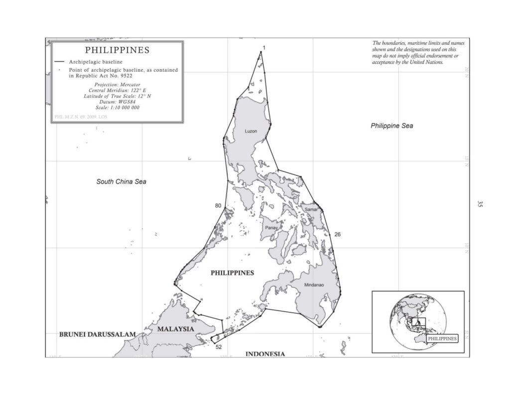
(English version) The Philippines Republic Act No. 9522 of 28 July 2008 to Define the Archipelagic Baselines and for other Purposes
- Summary
This legal document contains "Republic Act No. 9522 of 28 July 2008 to Define the Archipelagic Baselines of the Philippines and for other Purposes". Section 1 of this RA shall be the amendment for Section 1 of RA No. 3046 and Section 1 of RA No. 5446 which amended RA No. 3046.
Notably, in this RA No. 9522, the Kalayaan Island Group and the Scarborough Shoal are treated as "Regime of Islands", as provided in Article 121 of UNCLOS. Therefore, their baselines are no longer a part of the Philippines' archipelagic baselines. This change also signifies the Philippines' respect for Article 5 of the ASEAN Declaration on the Conduct of Parties in the South China Sea. Finally, Section 1 of this RA has revised the Philippines' archipelagic baselines from Section 1 of RA No. 3046 and 5446 that there is no baseline of the archipelagic baselines enclosing archipelago that exceeds 125 nautical miles, as provided in Article 47 of UNCLOS 1982. In RA No. 3046 (in 1961) and 5446 (in 1968), Line 27 (TONGQUILI.-Sumbasumba I.) was 259,400 Metres (140.065 nautical miles), which had not been revised since 1982 until the adoption of RA No. 9522 in 2008.
(English version) The Philippines: Republic Act No. 5446 of 18 September 1968 to Amend Section 1 of Republic Act 3046 (adopted from UN Treaty Series)
- Summary
This legal document contains Republic Act (RA) No. 5446 of 18 September 1968 to Amend Section 1 of Republic Act 3046, which was to define the baselines of the Territorial Sea of the Republic of the Philippines. Section 1 of RA No. 3046 was amended in this RA No. 5446 for typological error. The basepoint and baselines of the territorial sea- not the 'archipelagic baseline' - of this RA No. 5446 are the same as those in RA No. 3046.
Notably, this RA was established before UNCLOS III with the legal framework for archipelagic states and associated legal concepts in 1982. This explains the use of the word "baselines of the territorial sea" rather than "archipelagic baseline" in both RA No. 3046 and 5446. Therefore, while the length of Line 27 (TONGQUILI.-Sumbasumba I.) was 259,400 Metres (140.065 nautical miles), exceeding the limit of 125 nautical miles for baselines enclosing archipelago provided in Article 47 of 1982 UNCLOS, this was not a violation of UNCLOS at the time of promulgation. However, this became a violation of UNCLOS until 2008 when the Philippines adopts RA No. 9522 amending RA No. 3046 and No. 5446 to [re]define the archipelagic baselines.
- Documents: RA No. 5446 of 18 September 1968 to Amend Section 1 of Republic Act 3046 (adopted from UN Treaty Series)
- Amends: RA No. 3046 of 17 June 1961 to Define the Baselines of the Territorial Sea of the Republic of the Philippines (adopted from UN Treaty Series)