Joint submission by Malaysia and Vietnam to the Commission on the Limits of the Continental Shelf made on 6 May 2009 - in the southern part of the South China Sea (Executive Summary)
- Summary:
This legal document contains the Executive Summary of the Joint Submission by Malaysia and Vietnam to the Commission on the Limits of the Continental Shelf (CLCS) regarding their continental shelf in the Southern part of the South China Sea (SCS). In the defined area in the southern part of the SCS mentioned in the document and illustrated in Map/Figure 1 of the document (p.5), the continental shelf of the two countries extends beyond 200 nautical miles and overlaps. Besides the overlapping continental shelves, in Section 4, the two countries also acknowledge that (1) there are unresolved disputes within the defined area in Figure 1 between Vietnam-Malaysia and between each of the two countries with another/other third state party. (the Philippines and China). From page 6 onwards, is Table 1 annexed to the Document specifying geographic coordinates in World Geodetic System 1984 (WGS84).

- Document: Executive Summary of the Joint submission by Malaysia and Vietnam to the Commission on the Limits of the Continental Shelf made on 6 May 2009 - in the southern part of the South China Sea
- Related Documents:
Malaysia's Declaration upon Ratification of UNCLOS on 14 October 1996
- Summary
This legal document contains the Declaration upon Ratification of UNCLOS of the Government of Malaysia in accordance with article 310 of the United Nations Convention on the Law of the Sea on 14 October 1996. In the Declaration, the Government of Malaysia acknowledges their understanding and/or interpretations of the UNCLOS and its articles, namely Article 22, 23, 56, 74, 76, 83, 233, 301, 303.
- Document: Malaysia's Declaration upon Ratification of UNCLOS on 14 October 1996 (text adopted from UN)
(English version) Malaysia Territorial Sea Act 2012 (Act 750)
- Summary
This legal document contains the Territorial Sea Act 2012 (Act 750), published in the Gazette on 22 June 2012 by the Parliament of Malaysia to provide for the territorial sea of Malaysia and associated regards. This Territorial Sea Act 2012 was enacted by the parliament of Malaysia as Ordinance No. 7 in 1969 which was promulgated to make regulations cease to have an effect. The Act consists of 7 Sections. Section 1; Short title, commencement and application. Section 2: Interpretation of terms. Section 3: Limits of the territorial sea. Section 4: Sovereignty in respect of the territorial sea. Section 5: Maps and charts of limits of the territorial sea. Section 6: References to territorial waters in any other written law, etc. Section 7: Power to make regulations.
Subsection (3) of Section 3 provides the same provisions as the replaced Ordinance No. 7 that the "territorial waters" mentioned in and for the purpose of the Continental Shelf Act 1966, the Petroleum Mining Act 1966, and the National Land Code and written laws relating to the land of Sarawak and Sabah shall be up to only 3 nautical miles.
(English version) Malaysia Baselines of Maritime Zones Act 2006 (Act 660) on 31 December 2006
- Summary
This legal document contains the English version of Malaysia Baselines of Maritime Zones Act 2006 (Act 660), published in the Gazette on 31 December 2006. This Act was adopted "for the declaration of geographical coordinates of base points for the purpose of determining the baselines of Malaysia and for other matters connected therewith". This Act consists of 9 Sections. Section 1: Short title and commencement. Section 2; Interpretation of terms. Section 3: Prevailing law. Section 4; Geographical coordinates of base points. Section 5: Baselines. Section 6: Limits of maritime zones. Section 7: Limits of maritime zones. Section 9; Certificate of Minister. Section 9: Regulations.
(English version) Malaysian Maritime Enforcement Agency Act 2004 (Act 633)
- Summary
This legal document contains the English version of the Malaysian Maritime Enforcement Agency Act 633, published in the Gazette on 1 July 2004. This Act 633 is to Malaysian Maritime Enforcement Agency to enforce maritime laws and monitor the Malaysian Maritime Zones. The document consists of 4 Parts. Part I: Preliminary, which includes the Act title and interpretation of terms. Part II: establishment of Agency and Appointments. Part II: Functions and Power of The Agency. Part IV: General Provisions and Regulations.
(English version) Malaysia Exclusive Economic Zone Act 1984 (Act 311)
*Fullname: Exclusive Economic Zone Act, 1984, Act No. 311 An Act pertaining to the exclusive economic zone and certain aspects of the continental shelf of Malaysia and to provide for the regulations of activities in the zone and on the continental shelf and for matters connected therewith.
- Summary
This legal document contains the Exclusive Economic Zone Act 1984 (Act 311) promulgated by the Malaysian Federal Government (MFG) in 1984. The Act consists of ten parts with each including interpretations of terms, regulations relating to maritime operations, sovereign rights and jurisdictions of the MFG, and the rights & responsibilities of Malaysian vessels, and of foreign vessels. Part I: Preliminary & interpretations of terms. Part II: The Exclusive Economic Zone (EEZ) with the interpretation of, the MFG's sovereign rights in and jurisdiction over, and prohibitions of activities in the EEZ. Part III: Fisheries. Part IV: Protection and Preservation of the Marine Environment. Part V: Marine Scientific Research. Part VI: Artificial Islands, Installations and Structures. Part VII: Submarine Cables and Pipelines. Part VIII: Enforcement. Part IX: Offences, Penalties, Legal Proceedings and Compensation. Part X: Miscellaneous.
This Act was adopted in 1984, before the ratification of the 1982 UNCLOS by the Malaysian Federal Government.
- Document: Malaysia Exclusive Economic Zone Act 1984 (Act 311) (English version, adopted from UN Treaty Series)
(English version) Emergency (Essential Powers) Ordinance No. 7 in 1969
- 28Summary
This legal document contains the English version of the Emergency (Essential Powers) Ordinance No. 7 1969, adopted by the Malaysian Federal Government in January 1969. This Ordinance declares that the breadth of the Malaysian territorial sea shall be 12 nautical miles except in specified areas which shall be measured in accordance with the Geneva Convention of 1958. Notably, the "territorial waters" mentioned in and for the purpose of the Continental Shelf Act 1966, the Petroleum Mining Act 1966, and the National Land Code and written laws relating to the land of Sarawak and Sabah, shall be up to only 3 nautical miles.
- Document: Emergency (Essential Powers) Ordinance No. 7 1969, adopted by the Malaysian Federal Government in January 1969 (English version, adopted from UN Treaty Series)
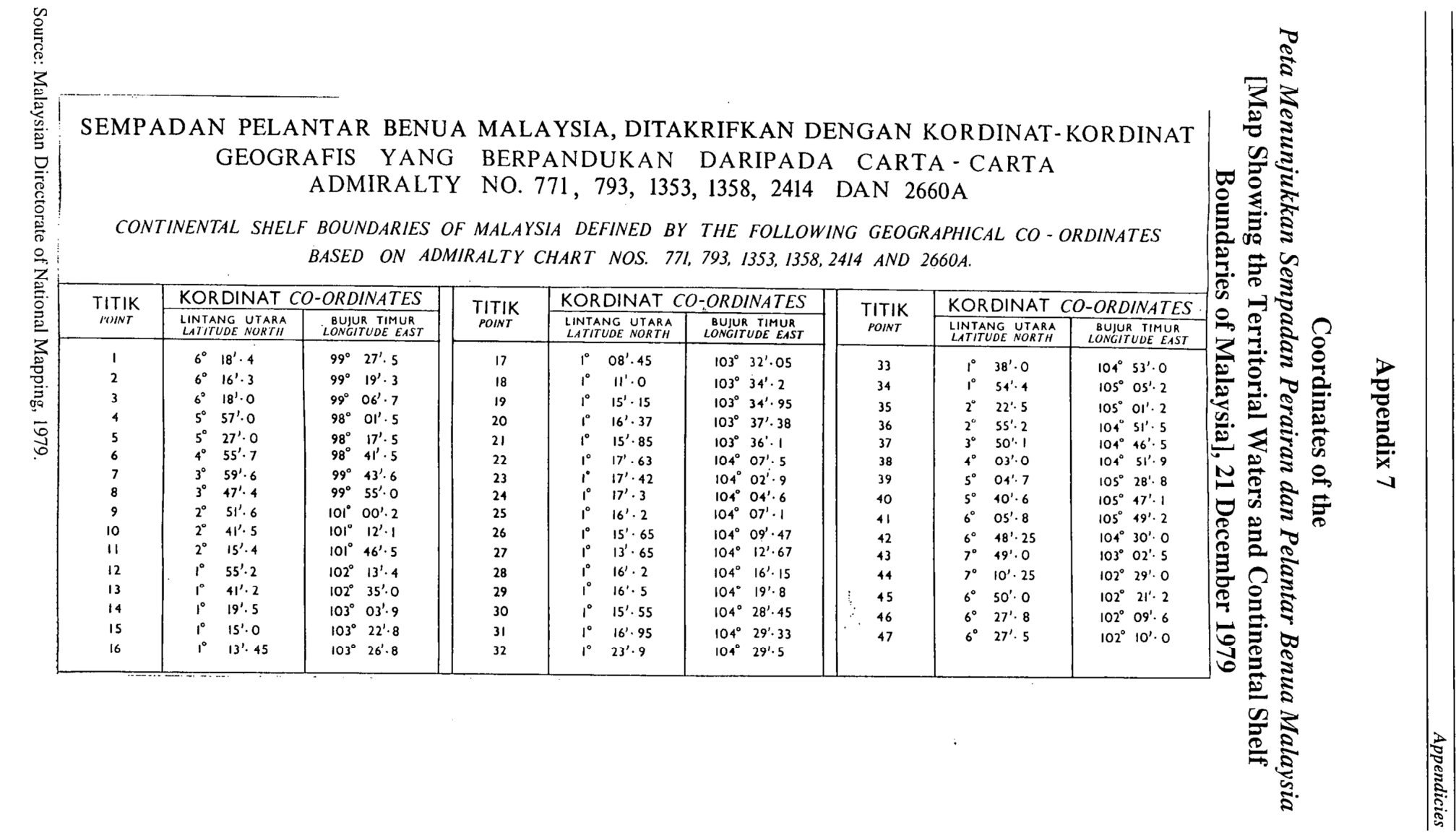
List of Continental Shelf Boundaries of Malaysia Defined by Geographical Coordinates
- Summary
This legal document contains the List of Continental Shelf Boundaries of Malaysia Defined by Geographical Coordinates, established on 21 December 1979.
- Related: Malaysia Continental Shelf Act 1966 - Act No. 57 on 28 July 1966, as Amended by Act No. 83 of 1972
(English version) Malaysia Continental Shelf Act 1966 - Act No. 57 on 28 July 1966, as Amended by Act No. 83 of 1972
- Summary
This legal document contains the English version of the Continental Shelf Act No.57 adopted by the Malaysian Federal Government on 28 July 1966 (thus the alternative name of "Act 1966"). The version of the Act in the document attached is the one after being amended by Act No.83 in 1972. The document includes the interpretation of "continental shelf", "natural resources", and "petroleum", and states the rights of the Federal Government with respect to the continental shelf, the regulation relating to petroleum exploitation & licensing,
- Document: Malaysia Continental Shelf Act 1966 - Act No. 57 on 28 July 1966, as Amended by Act No. 83 of 1972 (English version, adopted from UN Treaty Series)
- Related: List of Continental Shelf Boundaries of Malaysia Defined by Geographical Coordinates, established on 21 December 1979.
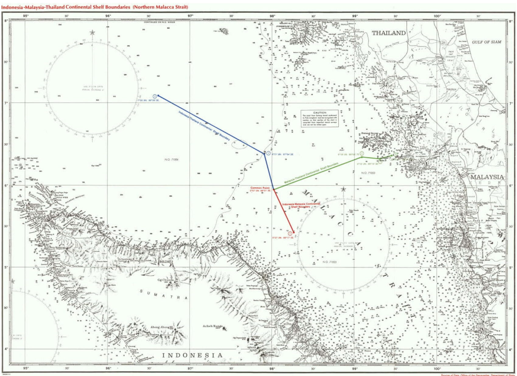
(English version) Agreement between Indonesia, Malaysia, and Thailand Relating to the Delimitation of the Continental Shelf Boundaries in the Northern Part of the Strait of Malacca on 21 December 1971
- Summary
This legal document contains the English version of the Agreement between the Government of the Republic of Indonesia, The Government of Malaysia, and the Government of the Kingdom of Thailand Relating to the Delimitation of the Continental Shelf Boundaries in the Northern Part of the Strait of Malacca signed on 21 December 1971. This Agreement concludes a common tripoint as a starting point for the continental shelves boundary between any two of the three parties. The coordinates of the tripoint are Latitude 5° 57.0' N Longitude 98° 01.5' E.
Article 1 provides that the continental shelves boundary between any two of the three parties shall extend to the tripoint, with the tripoint becoming the starting point of each boundary.