(Bahasa Indonesian version) Agreement between Indonesia and Philippines concerning the Delimitation of the Exclusive Economic Zone Boundary on 23 May 2014
This legal document contains the Bahasa Indonesian version of the Agreement between the Government of the Republic of Indonesia and the Government of the Republic of the Philippines concerning the Delimitation of the Exclusive Economic Zone (EEZ) Boundary signed in 2014.
The summary/description of the Agreement can be found in that of the English version of the Agreement.
Documents:
i. Agreement between the Government of the Republic of Indonesia and the Government of the Republic of the Philippines concerning the Delimitation of the Exclusive Economic Zone Boundary on 23 May 2014 (Bahasa Indonesian version, adopted from UN Treaty Series)
ii. Map visualizing the boundary of the EEZ agreed in the Agreement
(Visualizing map) Agreement between Indonesia and the Philippines concerning the Delimitation of the Exclusive Economic Zone Boundary on 23 May 2014
This document contains the mao visualizing the boundary of the Exclusive Economic Zone (EEZ) between the Republic of Indonesia and the Republic of the Philippines. The EEZ boundary between the two parties was agreed upon in the Agreement between the Government of the Republic of Indonesia and the Government of the Republic of the Philippines concerning the Delimitation of the Exclusive Economic Zone Boundary, signed in 2014.
Documents:
i. Agreement between the Government of the Republic of Indonesia and the Government of the Republic of the Philippines concerning the Delimitation of the Exclusive Economic Zone Boundary on 23 May 2014 (English version, adopted from UN Treaty Series)
ii. Map visualizing the boundary of the EEZ agreed in the Agreement
(English version) Agreement between Indonesia and the Philippines concerning the Delimitation of the Exclusive Economic Zone Boundary on 23 May 2014
- Summary
This legal document contains the English version of the Agreement between the Government of the Republic of Indonesia and the Government of the Republic of the Philippines concerning the Delimitation of the Exclusive Economic Zone (EEZ) Boundary signed in 2014. This Agreement entered into force on August 1st 2019, by the exchange of the instruments of ratification. The EEZ boundary between two contracting parties is comprised of 8 points, the latitude, and longitude of which are provided in the document. The map visualizing that boundary can be found here.
Notably, Article 1.3 clarifies that "This Agreement shall not prejudice any rights or positions of Contracting Parties with regard to the delimitation of the Continental Shelves boundary." This is reflected in the absence of an Agreement of delimitation of continental shelves between the Republic of Indonesia and the Republic of the Philippines.
- Documents:
i. Agreement between the Government of the Republic of Indonesia and the Government of the Republic of the Philippines concerning the Delimitation of the Exclusive Economic Zone Boundary on 23 May 2014 (English version, adopted from UN Treaty Series)
ii. Map visualizing the boundary of the EEZ agreed in the Agreement
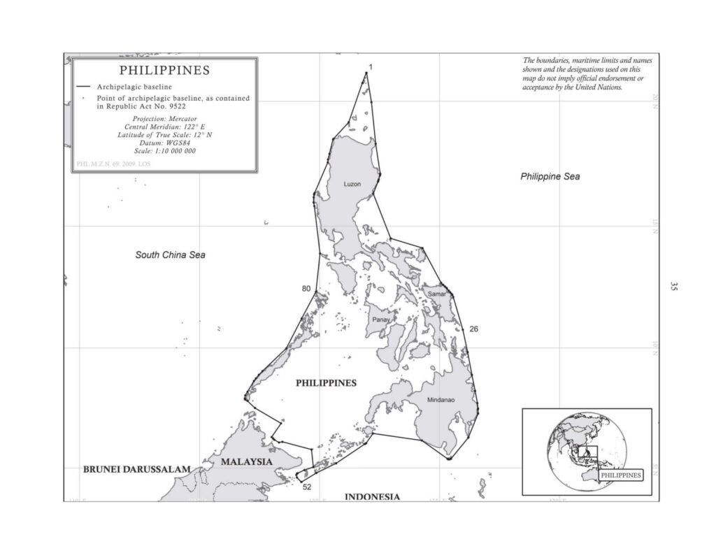
(English version) The Philippines Republic Act No. 9522 of 28 July 2008 to Define the Archipelagic Baselines and for other Purposes
- Summary
This legal document contains "Republic Act No. 9522 of 28 July 2008 to Define the Archipelagic Baselines of the Philippines and for other Purposes". Section 1 of this RA shall be the amendment for Section 1 of RA No. 3046 and Section 1 of RA No. 5446 which amended RA No. 3046.
Notably, in this RA No. 9522, the Kalayaan Island Group and the Scarborough Shoal are treated as "Regime of Islands", as provided in Article 121 of UNCLOS. Therefore, their baselines are no longer a part of the Philippines' archipelagic baselines. This change also signifies the Philippines' respect for Article 5 of the ASEAN Declaration on the Conduct of Parties in the South China Sea. Finally, Section 1 of this RA has revised the Philippines' archipelagic baselines from Section 1 of RA No. 3046 and 5446 that there is no baseline of the archipelagic baselines enclosing archipelago that exceeds 125 nautical miles, as provided in Article 47 of UNCLOS 1982. In RA No. 3046 (in 1961) and 5446 (in 1968), Line 27 (TONGQUILI.-Sumbasumba I.) was 259,400 Metres (140.065 nautical miles), which had not been revised since 1982 until the adoption of RA No. 9522 in 2008.
(English version) The Philippines: Republic Act No. 5446 of 18 September 1968 to Amend Section 1 of Republic Act 3046 (adopted from UN Treaty Series)
- Summary
This legal document contains Republic Act (RA) No. 5446 of 18 September 1968 to Amend Section 1 of Republic Act 3046, which was to define the baselines of the Territorial Sea of the Republic of the Philippines. Section 1 of RA No. 3046 was amended in this RA No. 5446 for typological error. The basepoint and baselines of the territorial sea- not the 'archipelagic baseline' - of this RA No. 5446 are the same as those in RA No. 3046.
Notably, this RA was established before UNCLOS III with the legal framework for archipelagic states and associated legal concepts in 1982. This explains the use of the word "baselines of the territorial sea" rather than "archipelagic baseline" in both RA No. 3046 and 5446. Therefore, while the length of Line 27 (TONGQUILI.-Sumbasumba I.) was 259,400 Metres (140.065 nautical miles), exceeding the limit of 125 nautical miles for baselines enclosing archipelago provided in Article 47 of 1982 UNCLOS, this was not a violation of UNCLOS at the time of promulgation. However, this became a violation of UNCLOS until 2008 when the Philippines adopts RA No. 9522 amending RA No. 3046 and No. 5446 to [re]define the archipelagic baselines.
- Documents: RA No. 5446 of 18 September 1968 to Amend Section 1 of Republic Act 3046 (adopted from UN Treaty Series)
- Amends: RA No. 3046 of 17 June 1961 to Define the Baselines of the Territorial Sea of the Republic of the Philippines (adopted from UN Treaty Series)
(English version) The Philippines: Republic Act (RA) No. 3046 of 17 June 1961 to Define the Baselines of the Territorial Sea of the Republic of the Philippines
- Summary
This legal document contains the Republic Act (RA) No. 3046 of 17 June 1961 to Define the Baselines of the Territorial Sea of the Republic of the Philippines. Section 1 of this RA was amended in RA No. 5446 of 18 September 1968 for typological error. The basepoint and baselines of the territorial sea- not the 'archipelagic baseline' - of RA No. 3046 is also included in RA No. 5446.
Notably, this RA was established before UNCLOS III with the legal framework for archipelagic states and associated legal concepts in 1982. This explains the use of the word "baselines of territorial sea" rather than "archipelagic baseline". Therefore, while the Line 27 (TONGQUILI.-Sumbasumba I.). Therefore, while the length of Line 27 (TONGQUILI.-Sumbasumba I.) was 259,400 Metres (140.065 nautical miles), exceeding the limit of 125 nautical miles for baselines enclosing archipelago provided in Article 47 of 1982 UNCLOS, this was not a violation of UNCLOS at the time of promulgation. However, this became a violation of UNCLOS until 2008 when the Philippines adopts RA No. 9522 amending RA No. 3046 and No. 5446 to [re]define the archipelagic baselines.
- Documents: RA No. 3046 of 17 June 1961 to Define the Baselines of the Territorial Sea of the Republic of the Philippines (English version, adopted from UN Treaty Series)
- Amended by: Republic Act No. 5446 of 18 September 1968 to Amend Section 1 of Republic Act 3046 (English version, adopted from UN Treaty Series)