(English version) Agreement between Indonesia and Papua New Guinea concerning Maritime Boundaries between the Two Countries and Cooperation on Related Matters on 13 December 1980
*This Agreement was signed between the Government of Papua New Guinea and of Indonesia in 1980 after the former had become an independent nation and ceased to be an UN-trusted territory under Australian administration in 1975.
**In this Agreement, Article 1 clarifies that the term "continental shelf" is used in accordant with International Law, and bears the same meaning as the term "seabed" used in the Seabed Boundary Agreement between Australia and Indonesia in 1971, 1972, 1973 relating to the "seabed" boundary between the two countries, which includes the boundary between Indonesia and Papua New Guinea.
- Summary
This legal document contains the Agreement between the Government of the Republic of Indonesia and the Government of Papua New Guinea concerning Maritime Boundaries between the Two Countries and Cooperation on Related Matters, signed on 13 December 1980.
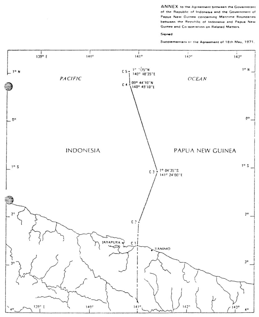
Article 2 of this Agreement, in order to further the continental shelf boundary between Indonesia and Papua New Guinea off the Northern Coast of the two countries from the groundwork (point C1 and C2) provided in Article 4 of the 1971 Australia-Indonesia Seabed Boundary Agreement, establishes point C3, C4, and C5. Their coordinates are specified in the same Article.
Article 4 of this 1980 Agreement also clarifies that the continental shelf boundary (or seabed boundary) between the two countries provided in Article 2 of this 1980 Agreement, in Article 1, 3, and 4 of the 1972 Australia-Indonesia Seabed Boundary Agreement, and in Article 3 of the 1973 Australia-Indonesia Seabed Boundary Agreement shall be both the continental shelf boundary and Exclusive Economic Zone boundary between the two countries.
- Document: Agreement between Indonesia and Papua New Guinea concerning Maritime Boundaries between the Two Countries and Cooperation on Related Matters on 13 December 1980 (English version, adopted from UN Treaty Series)
- Related Document:
- Agreement between Australia and Indonesia Establishing Certain Seabed Boundaries on 18 May 1971
- (English version) 1972 Australia-Indonesia Agreement furthering the west section of the seabed boundary agreed in 1971
- (English version) 1973 Australia-Indonesia Agreement completing the boundary line between Indonesia and Papua New Guinea for the southern coast.
(English version) Agreement between Australia and Indonesia concerning Certain Boundaries between Papua New Guinea and Indonesia on 12 February 1973
*Note: This Agreement was signed in 1973 when Papua New Guinea was still an Australian-administered United Nations trust territory (hence called “Trust territory of Papua New Guinea in the Agreement). It was on 15 September 1975 that established an official independent nation of Papua New Guinea.
- Summary
This legal document contains the English version of the Agreement between Australia and Indonesia concerning Certain Boundaries between Papua New Guinea and Indonesia, signed on 12 February 1973. In this Agreement, there are two boundaries established between Indonesia and Papua New Guinea (Australia-administered). The first one is the boundary on the island of Papua New Guinea, as provided in Article 1 with specific coordinates.
The second boundary is the sea bed boundary in the area of seabed that is adjacent to and appertains to Papua New Guinea and the area that is adjacent to and appertains to Indonesia, in the southern coast of Papua New Guinea/Indonesia on the island of Papua New Guinea. This boundary is provided in Article 3, with the establishment of points B2 and B3, which fulfills the seabed boundary in the same area whose groundwork (point B1) was provided in Article 3 of the 1971 Australia-Indonesia Seabed Agreement.
- Document: Agreement between Australia and Indonesia concerning Certain Boundaries between Papua New Guinea and Indonesia on 12 February 1973 (English version, adopted from UN Treaty Series)
- Alternative Document Language:
- Related Article: 1971 Australia-Indonesia Seabed Boundary Agreement.
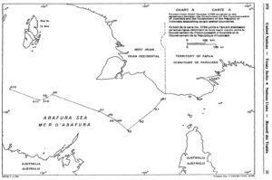
(English version) Agreement between Australia and Indonesia Establishing Certain Seabed Boundaries in the Area of The Timor and Arafura Seas on 9 October 1972, Supplementary to the Agreement of 18 May 1971
*Note: This Agreement was signed in 1972 when Papua New Guinea was still an Australian-administered United Nations trust territory (hence called “Trust territory of Papua New Guinea in the Agreement). It was on 15 September 1975 that established an official independent nation of Papua New Guinea.
- Summary
This legal document contains the English version of the Agreement between the Government of the Common Wealth of Australia and the Government of the Republic Of Indonesia Establishing Certain Seabed Boundaries in the Area of The Timor and Arafura Seas, signed on 9 October 1972. First, This 1972 Agreement is considered supplementary to the Agreement of 18 May 1971, specifically Article 2. The seabed boundary between the two parties in this 1972 Agreement extends westward from point A12, which was the most western point of the agreed boundary in the 1971 Agreement, to point A13, A14, A15, and A16. The specific coordinates of those points are provided in Article 1,
Second, Article 2 of this 1972 Agreement also establishes another seabed boundary between the two countries in the area south of the Roti and Timor Islands. The boundary consists of straight lines connecting points whose coordinates are specified in the same Article.
Visualizing Map: Left: 1972 Agreement's Map; Right: 1971 Agreement's Map
- Document: Agreement between Australia and Indonesia Establishing Certain Seabed Boundaries in the Area of The Timor and Arafura Seas on 9 October 1972, Supplementary to the Agreement of 18 May 1971 (English version, adopted from UN Treaty Series)
- Related Document:
- Alternative Language Document:
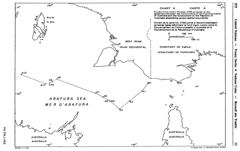
(English version) Agreement between Australia and Indonesia Establishing Certain Seabed Boundaries on 18 May 1971
*Note: This Agreement was signed in 1971 when Papua New Guinea was still an Australian-administered United Nations trust territory (hence called "Trust territory of Papua New Guinea in the Agreement). It was on 15 September 1975 that established an official independent nation of Papua New Guinea.
- Summary
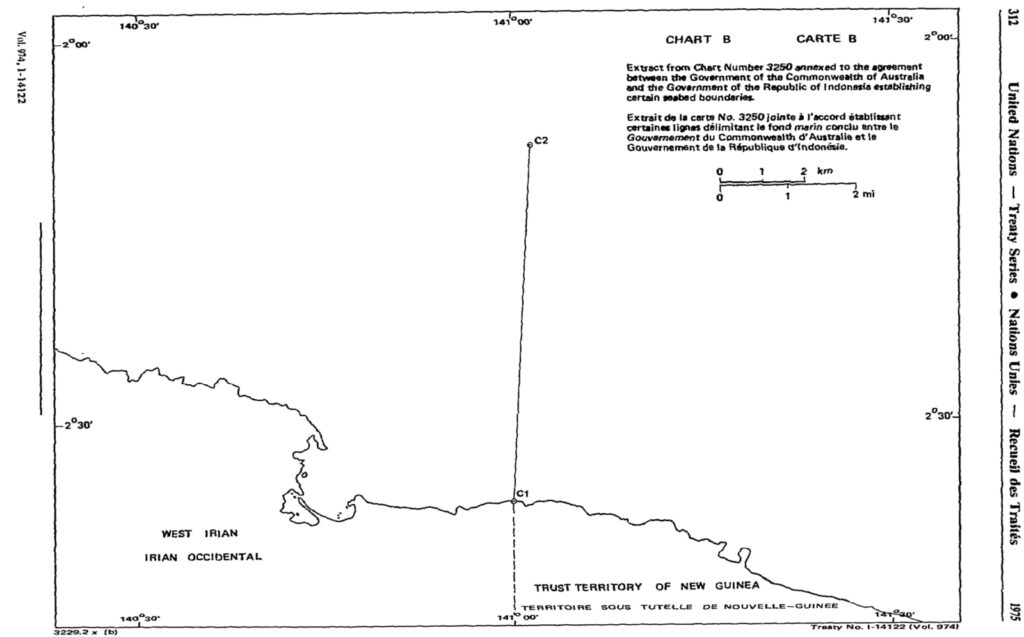
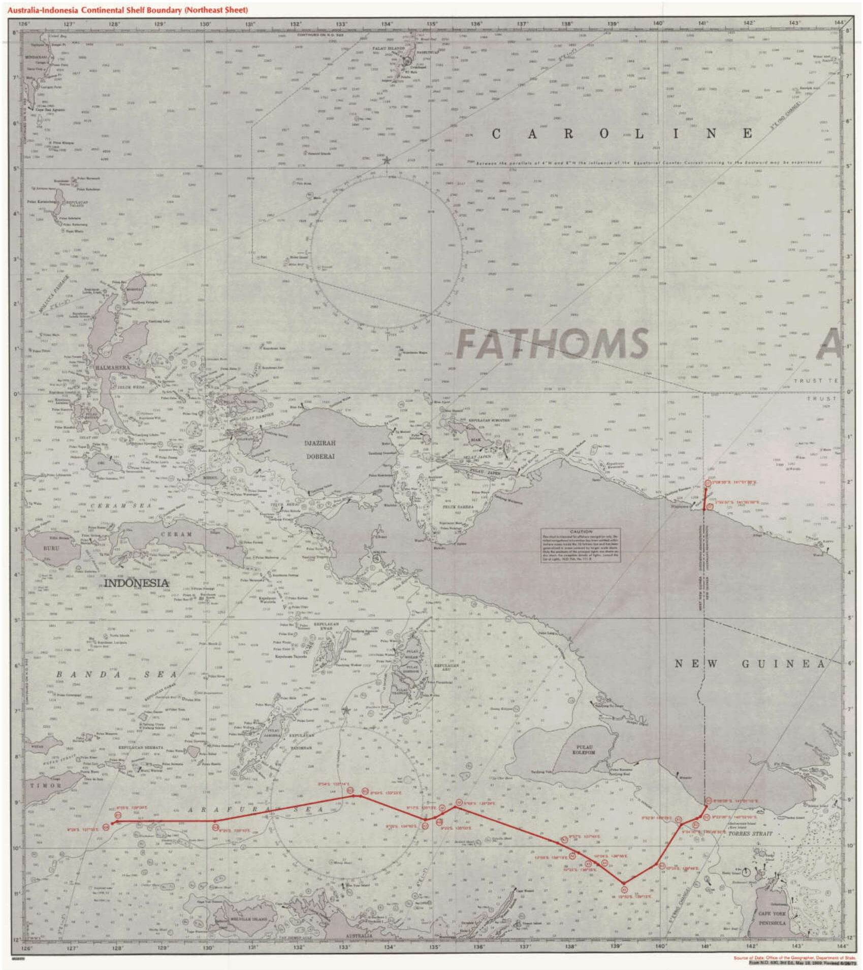
This legal document contains the English version of the Agreement between the Government of the Common Wealth of Australia and the Government of the Republic of Indonesia Establishing Certain Seabed Boundaries, signed on 18 May 1971. The agreed seabed boundary consists of straight lines connecting 12 points (A1 to A12) located between Longitude 133° 23' East of point A12 and Longitude 140° 29' East of point A1. Specific coordinates of the points constituting the agreed seabed boundary are provided in Article 1.
Notably, Article 2 states that the demarcation line of the seabed western to point A12 is not provided in this Agreement, and shall be negotiated in the future, which would be done in another bilateral Agreement in 1972.
The groundwork for seabed delimitation between Indonesia and the Trust Territory of Papua New Guinea is also partly provided in Article 3 (Southern coast of New Guinea adjacent to Indonesia's) and Article 4 (Northern coast of Newguinea adjacent to). The boundary lines for the southern coast of Papua New Guinea adjacent to Indonesia's coast would be completed in another Australia-Indonesia Agreement in 1973. The boundary line for the northern coast of Papua New Guinea adjacent to Indonesia's coast would be done in 1980 between the Government of Indonesia and of Papua New Guinea.
- Document: Agreement between the Government of the Common Wealth of Australia and the Government of the Republic of Indonesia Establishing Certain Seabed Boundaries on 18 May 1971 (English version, adopted from UN Treaty Series)
- Related Articles:
- (English version) 1972 Australia-Indonesia Agreement furthering the west section of the seabed boundary agreed in 1971
- (English version) 1973 Australia-Indonesia Agreement completing the boundary line between Indonesia and Papua New Guinea for the southern coast.
- (English version) 1980 Indonesia-Papua New Guinea Agreement establishing Maritime Boundary and furthering the boundary line between the two countries for the northern coast.
- Alternative Document Language:
(Unofficial English translation) Vietnam Law on Natural Resources and Environment of Sea and Islands on 25 June 2013
*The document attached is the unofficial translation of Vietnam's Law on Natural Resources and Environment of Sea adopted from economica.vn, which should be used for reference to grasp the content of the Law.
- Summary
This document contains the English version of Vietnam's Law on Natural Resources and Environment of Sea and Islands - Law No. 82/2015/QH13, promulgated by the National Assembly of Vietnam on 25 June 2013. The Law consists of 10 Chapters with 80 Articles.
Chapter I (Article 1-8): General Provisions
Chapter II (Article 9- 11): Strategy for Exploitation and Sustainable Use of Natural Resources and Environment of Sea and Island.
Chapter III (Article 12-21): Fundamental Investigation, Scientific Research on Resource and Environment,
Chapter IV (Article 22-38): General Plan for Exploitation and Sustainable Use of Natural Resources in Littoral Zones.
Chapter V (Article 39-41): Management of Natural Resources and Islands.
Chapter VI (Article 42-63) Control of Pollution, Coping with Spill of Oil, Toxic Chemicals, and Sea Dumping.
Chapter VII (Article 43-70): General Monitoring And Supervision, Information And Database System On Natural Resources And Environment Of Sea And Islands
Chapter VIII (Article 71-72): International Cooperation On Natural Resources And Environment Of Sea And Islands
Chapter IX (Article 73-78): Responsibilities For General Management Of Natural Resources And Environment Of Sea And Islands.
Chapter X (Chapter 79-80): Implementary Provisions.
- Document: Vietnam's Law on Natural Resources and Environment of Sea and Islands - Law No. 82/2015/QH13 on 25 June 2013 (Unofficial English translation, adopted from economica.vn)
Decree No. 71 on Management of Activities of Persons, Vehicles, and Craft in Maritime Boundary Areas of the Socialist Republic of Vietnam
- Summary
This legal document contains the English version of the Socialist Republic of Vietnam's Decree No. 71 on Management of Activities of Persons, Vehicles, and Craft in Maritime Boundary Areas of the Socialist Republic of Vietnam, promulgated by the Government of Vietnam on 3 September 2015. The Decree consists of 4 Chapters and 30 Articles. Chapter I: General Provisions. Chapter II: Management of Activities of Persons, Vehicles, and Craft in Maritime Boundary Areas. Chapter III: Responsibilities to Build, Manage, and Protect Maritime Boundary Areas [of different Ministries]. Chapter IV: Implementary Provisions.
- Document: Vietnam's Decree No. 71 on Management of Activities of Persons, Vehicles, and Craft in Maritime Boundary Areas of the Socialist Republic of Vietnam (adopted from vanbanphapluat.co)
(English version) Vietnam Maritime Code - Law No. 95/2015/QH13 on 25 November 2015
- Summary
This legal document contains the English version of the Socialist Republic of Vietnam's Maritime Code - Law No. 95/2015/QH13, promulgated by the 13th National Assembly of Vietnam on 25 November 2015. The Document is 124-page long, consists of 20 Chapters, of which there are 341 Articles.
Chapter I (Article 1-12): General Provisions.
Chapter II (Article 13-49): Sea-going Ships.
Chapter III (Article 50-72): Crew Members and Seafarers.
Chapter IV (Article 73-104): Seaport.
Chapter V (Article 105-128): Maritime Safety, Security, Occupation, and Environmental Protection.
Chapter VI (Article 129-144): Arrest of Ships.
Chapter VII (Article 145-199): Contract for Carrying of Goods by Sea.
Chapter VIII (Article 200-214): Contract for Carriage of Passengers and Baggage by Sea.
Chapter IX (Article 215-234): Charter-Party.
Chap X (Article 235-246): Ship Agents and Shipbroking.
Chapter XI: (Article 247-255) Marine Pilotage.
Chapter XII (Article 256-263): Ship towage.
Chapter XIII (Artice 264-275): Marine rescue.
Chapter XIV (Article 276-284): Salvage of Shipwrecked Property.
Chapter XV (Article 285-291): Ship Collisions.
Chapter XVI (Article 292-297): General Average.
Chapter XVII (Article 298-302): Limitation of Liability for Maritime Claims.
Chapter XVIII (Article 303-336): Marine Insurance Contract.
Chapter XIX (Article 337-339): Resolution of Maritime Disputes.
Chapter XX (Article 340-341): Implementary Provisions
The law applies to Vietnamese organizations or individuals; overseas organizations or individuals engaging in maritime operations within the territory of Vietnam, as provided by Article 2, Chapter I.
- Document: Vietnam Maritime Code - Law No. 95/2015/QH13 on 25 November 2015 (English version, adopted from economica.vn)
- Related Article:
- Vietnamese version, Vietnam Maritime Code Part 1, from Law No. 95/2015/QH13 on 25 November 2015
- Vietnamese version, Vietnam Maritime Code Part 2, from Law No. 95/2015/QH13 on 25 November 2015
(English version) The Philippines: Executive Order No. 25 of 16 May 2017 for Changing the Name of "Bentham Rise" to "Philippine Rise" and for Other Purposes
- Summary
This legal document contains Executive Order No. 25 for Changing the Name of "Bentham Rise" to "Philippine Rise" and for Other Purposes, signed by the President of the Philippines Rodrigo Roa Duterte on 16 May 2017.
- Document: Executive Order No. 25 of 16 May 2017 for Changing the Name of "Bentham Rise" to "Philippine Rise" and for Other Purposes (English version, adopted from UN Treaty Series).
- Additional document: Circular Communication from The Secretary-General of the United Nations regarding the Philippines Rise name change
- Related Articles:
Memorandum Circula No. 94 on 17 March 2016 Creating the National Task Force for the West Philippine Sea
- Summary
This legal document contains the Memorandum Circula No. 94 for Creating the National Task Force for the West Philippine Sea,(NTF-WPS) established on 17 March 2016. The document consists of 7 Sections. Creation of the National task Force for the West Philippines Sea & Representatives/Chairperson Members. Section 2: Functions of the NTF-WPS. Section 3: Creation of Area-level and tactical-level task Force. Section 4: Support and Cooperation. Section 5: Separability of provisions' validity. Section 6: Repeal any regulations, rules, and proclamations that are inconsistent with any provision of this Circula. Section 7: Effectivity: The Circula takes effect immediately
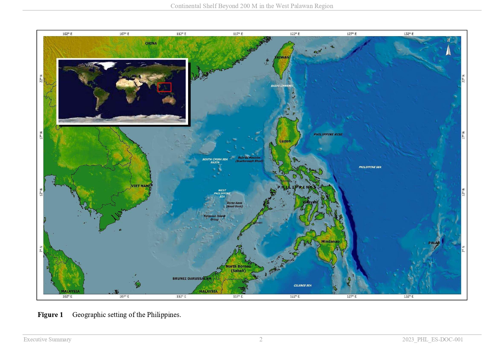
The Philippines' Partial Submission to the CLCS on Data and Information on the Outer Limit of the Continental Shelf in the West Palawan Region (14 June 2024)
- Summary
This legal document contains the Executive Summary of the Philippines's Partial Submission of Data and Information on the Outer Limits of the Continental Shelf of the Republic of the Philippines beyond 200 Nautical Miles in the West Palawan Region, submitted on 14 June 2024.
The West Palawan Region mentioned in the Document is visualized as in the below image.
 Document: (Executive Summary) The Philippines' Partial Submission to the CLCS on Data and Information on the Outer Limit of the Continental Shelf in the West Palawan Region (14 June 2024)
- Related Documents: (Executive Summary) the Philippines's Partial Submission of Data and Information on the Outer Limits of the Continental Shelf in the Benham Rise (Philippine Rise) Region Eastern to Luzon Island