(VNM-C) Vietnam's Partial Submission to the Commission on the Limits of the Continental Shelf in Respect of the Central Area (Executive Summary)
Summary:
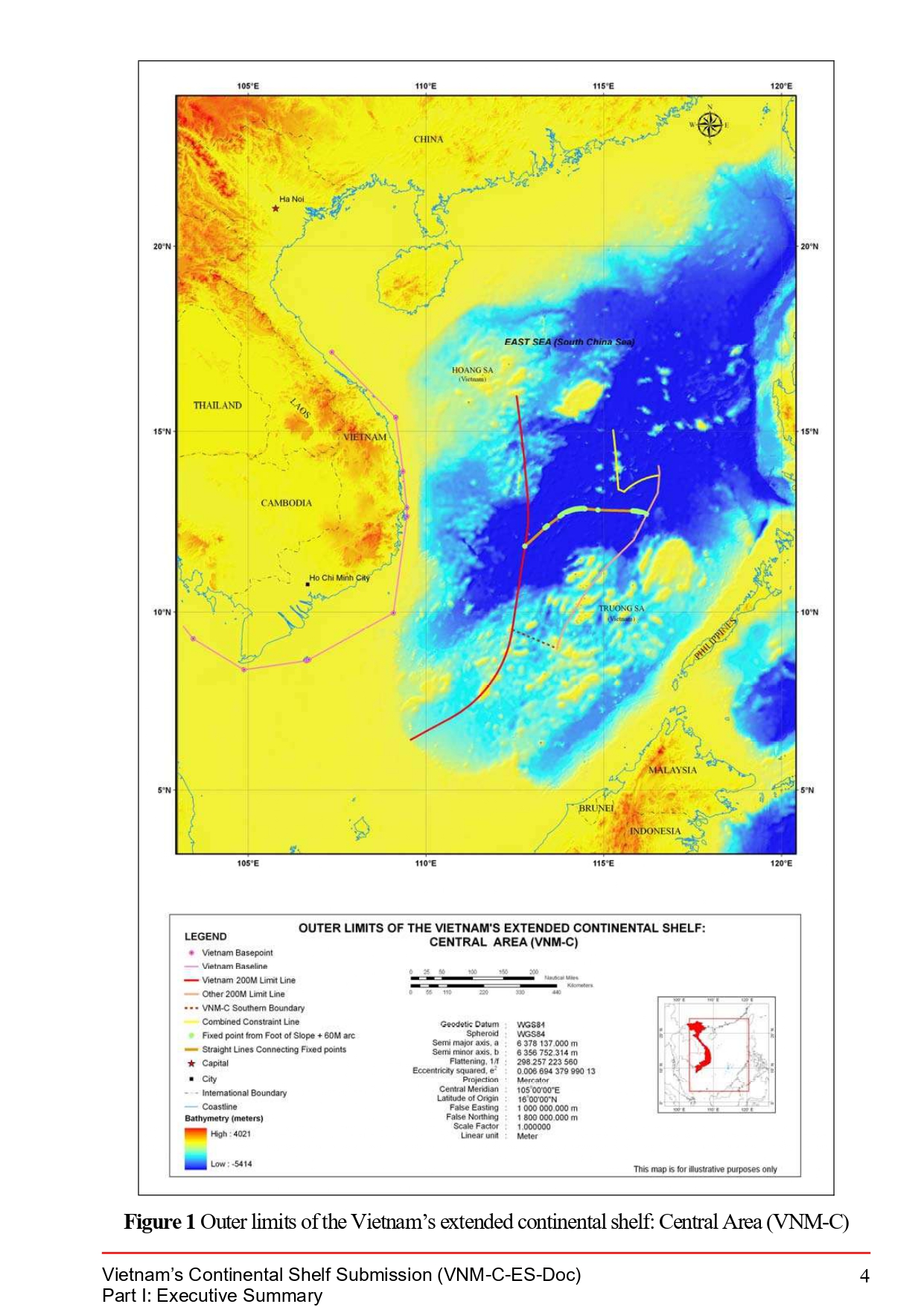
This legal document contains the Executive Summary of Vietnam's submission to the CLCS regarding the information on the limits of Vietnam's continental shelf beyond 200 nautical miles in the Central area of the South China Sea (marked as VNM-C), submitted on July 17th, 2024. This submission was made fifteen years after the country's partial submission in the northern region of the South China Sea (VNM-N) and Joint submission between Malaysia and Vietnam in the southern part of the South China Sea (VNM-S). The area subjected in this partial document is illustrated in Figure 1 (p.4) attached below.
Noticeably, on the cover of the submission, the year of submission is indicated as "2009," which suggests that Vietnam implies this partial submission is a continuation to the previous two submissions made by the country in 2009.

- Document: Vietnam's Partial Submission to the Commission on the Limits of the Continental Shelf in Respect of the Central Area (Executive Summary)
- Related Documents:
(English version) IMO Navigation Rules at Straits of Malacca and Singapore, 14 November 1977
- Summary
This legal document contains Resolution A.375(X) of the International Maritime Organization/IMO (at the time named Inter-governmental Maritime Consultative Organization), adopted on 14 November 1977. This Resolution is also known as IMO Navigation Rules at Straits of Malacca and Singapore.
The Resolution includes, inter alia, coordinates constituting the separation zones and traffic lanes in the two straits, rules for vessels navigating through the two straits, and a list of navigational aids to be installed or improved.
- Document: IMO Navigation Rules at Straits of Malacca and Singapore, 14 November 1977
- Related Document: 2010 ASEAN Declaration on Cooperation in Search and Rescue of Persons and Vessels in Distress at Sea
(English version) Thailand Proclamation establishing the Exclusive Economic Zone of the Kingdom of Thailand adjacent to the Exclusive Economic Zone of Malaysia in the Gulf of Thailand, 18 February 1988
- Summary
This legal document contains Thailand's Proclamation establishing the Exclusive Economic Zone of the Kingdom of Thailand adjacent to the Exclusive Economic Zone of Malaysia in the Gulf of Thailand, proclaimed on 18 February 1988.
This document provides the specific coordinates of the points constituting the outer limit of Thailand's Exclusive Economic Zone (EEZ) adjacent to Malaysia's EEZ in the Gulf of Thailand. Point 1 and 2 in this Proclamation is also the two points constituting the line delimiting the territorial sea of the two countries in Article II (1) of the Thailand-Malaysia territorial sea delimitation treaty in 1979
- Document: Thailand Proclamation establishing the Exclusive Economic Zone of the Kingdom of Thailand adjacent to the Exclusive Economic Zone of Malaysia in the Gulf of Thailand, 18 February 1988
- Related document: Thailand's Royal Proclamation establishing the Exclusive Economic Zone of the Kingdom of Thailand, 23 February 1981
(English version) Thailand Declaration of the Office of the Prime Minister concerning the Inner Part of the Gulf of Thailand, 22 September 1959
- Summary
This legal document contains Thailand's Declaration of the Office of the Prime Minister concerning the Inner Part of the Gulf of Thailand, promulgated on 22 September 1959. In this Declaration, the Council of Ministers of Thailand declared and maintain the position, from time immemorial, that a certain part of the inner part of the Gulf of Thailand has the judicial status as a historic bay, and thus the water enclosed will form part of Thailand's internal water.
Specific coordinates delimiting the said water part are provided in the Declaration.
(Bahasa Indonesian, Hindi, & Thai versions) Agreement between India. Indonesia, and Thailand Concerning the Determination of the Trijunction Point and the Delimitation of the Related Boundaries of the three Countries in the Andaman Sea on 22 June 1978
- Summary:
This legal document contains the Indonesian, Hindi, and Thai versions of the Agreement between India. Indonesia, and Thailand Concerning the Determination of the Trijunction Point and the Delimitation of the Related Boundaries of the three Countries in the Andaman Sea signed on 22 June 1978. Notably, Article 1 of the Agreement specifies the coordinates of the Trijunction point from which the continental shelf boundary between any two of the three state parties.
The continental shelf boundary between India and Indonesia will be extended from the trijunction point south-westerly to point 0 mentioned in Article 1 of the two countries' Agreement on the continental shelf boundary in 1974. The seabed boundary between Indonesia and Thailand will be extended from the trijunction point south-easterly to point L mentioned in Article 1 of the two countries' Agreement on seabed boundaries in 1975. The sea bed boundary between India and Thailand will be extended from the trijunction point north-easterly to point 1 of the two countries' Agreement on seabed boundary signed on the same day as this Trilateral Agreement.
- Document: Agreement between India. Indonesia, and Thailand Concerning the Determination of the Trijunction Point and the Delimitation of the Related Boundaries of the three Countries in the Andaman Sea on 22 June 1978 (Bahasa Indonesian, Hindi, & Thai version)
- Alternative document language: English

(VNM-N) Vietnam's Partial Submission to the Commission on the Limits of the Continental Shelf in Respect of the North Area in the South China Sea (Executive Summary)
Summary:
This legal document contains the Executive Summary of Vietnam's partial submission to the CLCS regarding Vietnam's continental shelf extending beyond 200 nautical miles in the north area of the South China Sea (SCS), submitted on May 7th, 2009. This partial submission was made one day after the Joint submission between Malaysia and Vietnam on their continental shelf extending beyond 200 nautical miles in the southern part of the South China Sea (also southern to the area subject to this partial submission of Vietnam). The area subjected in this partial document is illustrated in Figure 1 (p.5) attached below,
Noticeably, in Section 4 Absence of Disputes, the document states "the area of continental shelf which is the subject of this Submission is of overlapping interests expressed by relevant coastal States. Nevertheless, subject to the provisions of UNCLOS 1982, Vietnam is of the view that the area of continental shelf that is the subject of this Submission is not a subject of any overlap and dispute.".

- Document: Vietnam's Partial Submission to the Commission on the Limits of the Continental Shelf in Respect of the North Area in the South China Sea (Executive Summary)
- Related Documents:
Joint submission by Malaysia and Vietnam to the Commission on the Limits of the Continental Shelf made on 6 May 2009 - in the southern part of the South China Sea (Executive Summary)
- Summary:
This legal document contains the Executive Summary of the Joint Submission by Malaysia and Vietnam to the Commission on the Limits of the Continental Shelf (CLCS) regarding their continental shelf in the Southern part of the South China Sea (SCS). In the defined area in the southern part of the SCS mentioned in the document and illustrated in Map/Figure 1 of the document (p.5), the continental shelf of the two countries extends beyond 200 nautical miles and overlaps. Besides the overlapping continental shelves, in Section 4, the two countries also acknowledge that (1) there are unresolved disputes within the defined area in Figure 1 between Vietnam-Malaysia and between each of the two countries with another/other third state party. (the Philippines and China). From page 6 onwards, is Table 1 annexed to the Document specifying geographic coordinates in World Geodetic System 1984 (WGS84).

- Document: Executive Summary of the Joint submission by Malaysia and Vietnam to the Commission on the Limits of the Continental Shelf made on 6 May 2009 - in the southern part of the South China Sea
- Related Documents:
Memorandum Circula No. 94 on 17 March 2016 Creating the National Task Force for the West Philippine Sea
- Summary
This legal document contains the Memorandum Circula No. 94 for Creating the National Task Force for the West Philippine Sea,(NTF-WPS) established on 17 March 2016. The document consists of 7 Sections. Creation of the National task Force for the West Philippines Sea & Representatives/Chairperson Members. Section 2: Functions of the NTF-WPS. Section 3: Creation of Area-level and tactical-level task Force. Section 4: Support and Cooperation. Section 5: Separability of provisions' validity. Section 6: Repeal any regulations, rules, and proclamations that are inconsistent with any provision of this Circula. Section 7: Effectivity: The Circula takes effect immediately
Administrative Order No. 29 on 5 September 2012 Naming the West Philippine Sea of the Republic of the Philippines and for Other Purposes
- Summary
This legal document contains Administrative Order No. 29 for Naming the West Philippine Sea of the Republic of the Philippines and for Other Purposes, signed by the President of the Philippines Benigno S. Aquino III on 5 September 2012. The Administrative Order consists of 11 Sections. The maritime area that would be named the West Philippines Sea covers those on the western side of the Philippines archipelago, specifically the Luzon Sea as well as the waters around, within, and adjacent to the Kalayaan Island Group and Bajo De Masinloc, also known as Scarborough Shoal.
(English version) The Philippines: Presidential Decree No. 1596 of 11 June 1978 Declaring Certain Area Part of the Philippines Territory and Providing for their Government and Administration
- Summary
This legal document contains the Presidential Decree No. 1596 of the Philippines on 11 June 1978 Declaring Certain Area Part of the Philippine Territory and Providing for their Government and Administration. This decree was signed by President of the Philippines Ferdinand E. Marcos on 11 June 1978 and took effect immediately as provided in Section 3.
This Decree No. 1596 was established to specify the coordinates of and to name the cluster of island and islet as "Kalayaan Island Group" (KIG). This Decree clarifies that the KIG is part of the continental margin of the Philippines, vital to the security of the security and economy of the Philippines, and not legally claimed to be a part of any states or nations. Therefore, the KIG and its sea-bed, sub-soil, continental margin, and space shall be subject to the sovereignty of the Philippines, and be constituted as a separate municipality of the Province of Palawan.