(English & French version) Treaty between Australia and New Zealand establishing certain Exclusive Economic Zone and Continental Shelf Boundaries, 25 July 2004
- Summary
This legal document contains the English and French versions of the Treaty between Australia and New Zealand establishing certain Exclusive Economic Zone and Continental Shelf Boundaries, signed on 25 July 2004.
Article 1 of this Treaty contains the coordinates constituting the boundary between (1) New Zealand's Lord Howe Islands and the North Island and (2) Australia's Norfolk Island and Three Kings Islands, which are visualized in Annex I and II of the Treaty (1st and 2nd attached image.)
Article 2 of this Treaty contains the coordinates constituting the baseline between Macquarie Island and Auckland and Campell Island, which are visualized in Annex I and III of the Treaty (1st and 3rd attached image.)


(English version) Agreement on Maritime Delimitation between Australia and France on 4 January 1982
- Summary
This legal document contains the English version of the Agreement on Maritime Delimitation between Australia and France, signed on 4 January 1982.
Article 1 provides the coordinates constituting the maritime boundary (EEZ & Continental Shelf) between (1) Australia's islands in the Coral Sea, Norfolk Island, and other Australian islands and (2) France's New Caledonia, Chesterfield Islands, and other French islands.
Article 2 provides the coordinates constituting the maritime boundary (EEZ & Continental Shelf) between (1) Australia's Heard and McDonald Islands and (2) France's Kerguelen Islands.
Regarding the continental shelf, the final basepoint of each of the demarcation lines mentioned in Articles 1 and 2 of the Agreement does not imply the final point for the continental shelf boundary, if the continental shelf boundary needs to be extended in the future.
- Document: English version of Agreement on Maritime Delimitation between Australia and France on 4 January 1982
- Alternative document language: French version
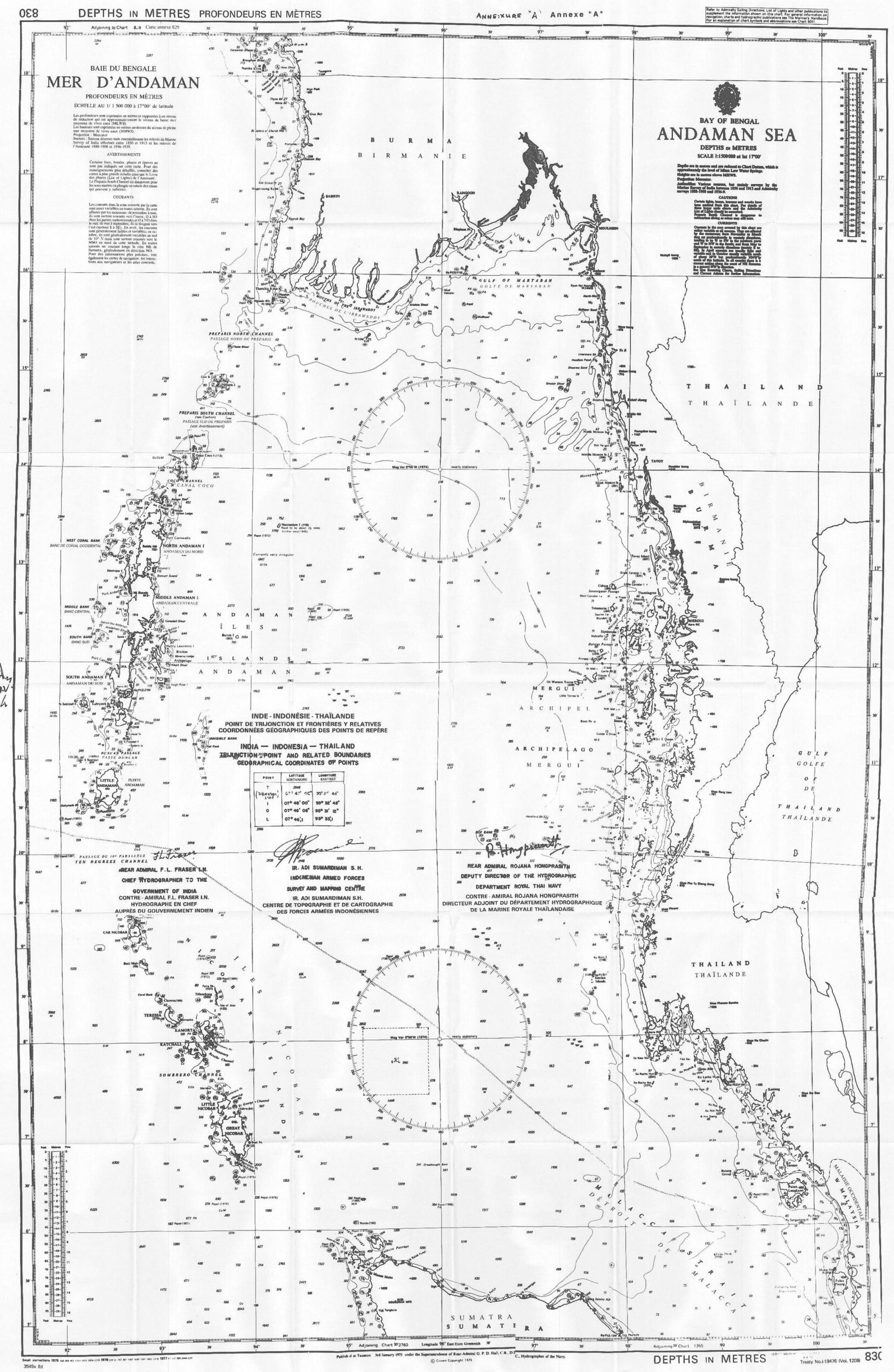
(English version) Agreement between India. Indonesia, and Thailand Concerning the Determination of the Trijunction Point and the Delimitation of the Related Boundaries of the three Countries in the Andaman Sea on 22 June 1978
- Summary:
This legal document contains the Agreement between India. Indonesia, and Thailand Concerning the Determination of the Trijunction Point and the Delimitation of the Related Boundaries of the three Countries in the Andaman Sea signed on 22 June 1978. Notably, Article 1 of the Agreement specifies the coordinates of the Trijunction point from which the continental shelf boundary between any two of the three state parties.
The continental shelf boundary between India and Indonesia will be extended from the trijunction point south-westerly to point 0 mentioned in Article 1 of the two countries' Agreement on the continental shelf boundary in 1974. The seabed boundary between Indonesia and Thailand will be extended from the trijunction point south-easterly to point L mentioned in Article 1 of the two countries' Agreement on seabed boundaries in 1975. The sea bed boundary between India and Thailand will be extended from the trijunction point north-easterly to point 1 of the two countries' Agreement on seabed boundary signed on the same day as this Trilateral Agreement.
- Document: Agreement between India. Indonesia, and Thailand Concerning the Determination of the Trijunction Point and the Delimitation of the Related Boundaries of the three Countries in the Andaman Sea on 22 June 1978 (English version)
- Alternative document languages: Bahasa Indonesian, Hindi, and Thai versions
(English version) Australia Proclamation of Outer Limits (Torres Strait) of 4 February 1983, pursuant to section 7 of the Seas and Submerged Lands Act 1973
- Summary
This legal document contains Australia's Proclamation of Outer Limits (Torres Strait) of 4 February 1983, pursuant to section 7 of the Seas and Submerged Lands Act 1973, promulgated on 4 February 1983. This document includes mainly the term definitions, regulations, and coordinates of the basepoints regarding the outer limits of the territorial sea adjacent to certain islands comprised within the State of Queensland.
- Document: Australia Proclamation of Outer Limits (Torres Strait) of 4 February 1983, pursuant to section 7 of the Seas and Submerged Lands Act 1973
- Related Documents:
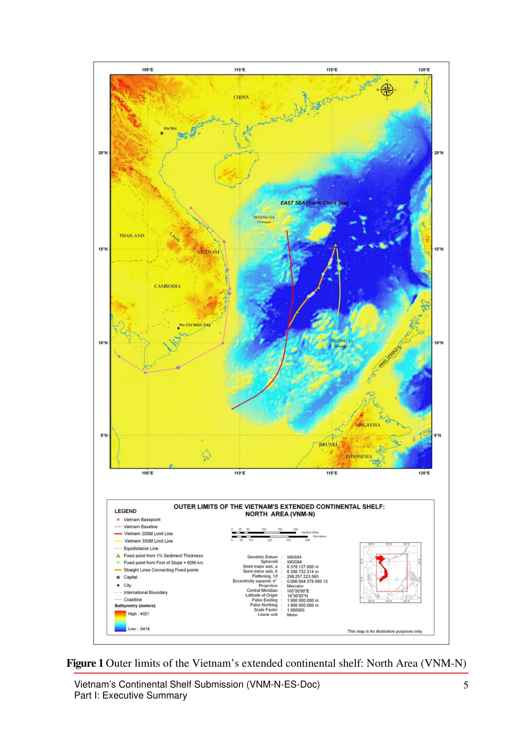
(VNM-N) Vietnam's Partial Submission to the Commission on the Limits of the Continental Shelf in Respect of the North Area in the South China Sea (Executive Summary)
Summary:
This legal document contains the Executive Summary of Vietnam's partial submission to the CLCS regarding Vietnam's continental shelf extending beyond 200 nautical miles in the north area of the South China Sea (SCS), submitted on May 7th, 2009. This partial submission was made one day after the Joint submission between Malaysia and Vietnam on their continental shelf extending beyond 200 nautical miles in the southern part of the South China Sea (also southern to the area subject to this partial submission of Vietnam). The area subjected in this partial document is illustrated in Figure 1 (p.5) attached below,
Noticeably, in Section 4 Absence of Disputes, the document states "the area of continental shelf which is the subject of this Submission is of overlapping interests expressed by relevant coastal States. Nevertheless, subject to the provisions of UNCLOS 1982, Vietnam is of the view that the area of continental shelf that is the subject of this Submission is not a subject of any overlap and dispute.".
- Document: Vietnam's Partial Submission to the Commission on the Limits of the Continental Shelf in Respect of the North Area in the South China Sea (Executive Summary)
- Related Documents:
Joint submission by Malaysia and Vietnam to the Commission on the Limits of the Continental Shelf made on 6 May 2009 - in the southern part of the South China Sea (Executive Summary)
- Summary:
This legal document contains the Executive Summary of the Joint Submission by Malaysia and Vietnam to the Commission on the Limits of the Continental Shelf (CLCS) regarding their continental shelf in the Southern part of the South China Sea (SCS). In the defined area in the southern part of the SCS mentioned in the document and illustrated in Map/Figure 1 of the document (p.5), the continental shelf of the two countries extends beyond 200 nautical miles and overlaps. Besides the overlapping continental shelves, in Section 4, the two countries also acknowledge that (1) there are unresolved disputes within the defined area in Figure 1 between Vietnam-Malaysia and between each of the two countries with another/other third state party. (the Philippines and China). From page 6 onwards, is Table 1 annexed to the Document specifying geographic coordinates in World Geodetic System 1984 (WGS84).

- Document: Executive Summary of the Joint submission by Malaysia and Vietnam to the Commission on the Limits of the Continental Shelf made on 6 May 2009 - in the southern part of the South China Sea
- Related Documents:
(English version) Agreement between India and Indonesia on the Extension of the 1974 Continental Shelf Boundary in the Andaman Sea and the Indian Ocean on 14 January 1977
This legal document contains the English version of the Agreement between India and Indonesia on the Extension of the 1974 Continental Shelf Boundary in the Andaman Sea and the Indian Ocean, signed on 14 January 1977. This Agreement, as described by its name, provides the extension of the continental shelves boundary between the two countries agreed in 1974. Article 1 reiterates the coordinates of the four points constituting the boundary in the Adaman sea agreed in 1974. Article 2 establishes the coordinates of four new points constituting a boundary that extends the boundary in Article 1 into the Indian Ocean.
- Document: Agreement between India and Indonesia on the Extension of the 1974 Continental Shelf Boundary in the Andaman Sea and the Indian Ocean on 14 January 1977 (English version, adopted from UN Treaty Series)
- Alternative Language: Bahasa Indonesian & Hindi version
(English version) Agreement relating to the Delimitation of the Continental Shelf Boundary between India and Indonesia on 8 August 1974
- Summary
This legal document contains the English version of the Agreement relating to the Delimitation of the Continental Shelf Boundary between India and Indonesia in the area between Great Nicobar (India) and Sumatra (Indonesia), signed on 8 August 1974. Article 1 provides the coordinates of the four points constituting the boundary agreed in the Agreement.
- Document: Agreement relating to the Delimitation of the Continental Shelf Boundary between India and Indonesia on 8 August 1974 (English version, adopted from UN Treaty Series)
- Alternative Language: Bahasa Indonesian & Hindi version
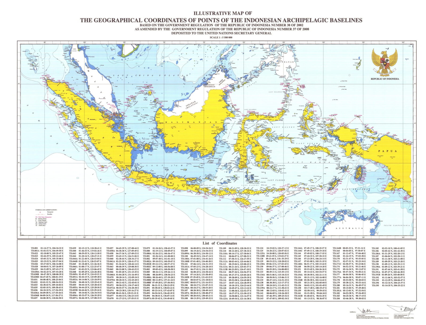
Indonesia: List and Illustrative Map of Geographical Coordinates of Points of the Indonesian Archipelagic Baselines
This legal document contains the first part of the List of Indonesia's Archipelagic Baselines Coordinates based on the Government Regulation of The Republic of Indonesia Number 38 of 2002 as Amended by the Government Regulation of The Republic of Indonesia Number 37 of 2008. There are 183 points whose coordinates are specified in this document. Page 21 includes the list of abbreviated terms, which are Kr. = Karang (Reef) M = Nautical Mile P. = Pulau (Island) S. = Sungai (River) Tg. = Tanjung Ug. = Ujung.
- Document:
(English version) Memorandum of Understanding between Indonesia and Australia concerning the Implementation of a Provisional Fisheries Surveillance and Enforcement Arrangement on 29 October 1981
- Summary
This legal document contains the English version of the Memorandum of Understanding (MoU) between the Government of the Republic of Indonesia and the Government of Australia concerning the Implementation of a Provisional Fisheries Surveillance and Enforcement Arrangement signed on 29 October 1981.
This MoU concludes with the establishment of a Provisional Fisheries Surveillance and Enforcement line in the Timor Sea where the 200-Nautical mile Exclusive Economic Zones of the two countries overlap. Notably, Article 6 clarifies that "this arrangement is provisional in nature ... and does not affect the limits of the 200-nautical mile [exclusive economic] zones established by either country."
- Document: Memorandum of Understanding between Indonesia and Australia concerning the Implementation of a Provisional Fisheries Surveillance and Enforcement Arrangement on 29 October 1981
- Related Article: Agreement between Australia and Indonesia Establishing Certain Seabed Boundaries in the Area of The Timor and Arafura Seas on 9 October 1972, Supplementary to the Agreement of 18 May 1971